
Historical Markers
If you have historical marker photos from McMullen County and would like to donate them for use on this project please send them to the McMullen County Coordinator
The Historical Marker Information comes from theTexas
Historical Commission
Index to Historical Markers in McMullen County.
|
|
Marker Title: | McMullen County, Historic Courthouse |
|
Marker Photo Currently Available |
Photos: | McMullen County Courthouse Past and Present |
| City: | Tilden | |
| Current Use: | Active Courthouse | |
| Owner: | County | |
| Style: | Classical Revival with Mission influences | |
| Description: |
Dark brick with limestone
water table, window lintels and sills. Symmetrical facades with shall temple
entries supported by Doric columns. Four square plan with corbelled chimneys
and curvilinear dormers. Original pressed metal ceilings in courtroom.
|
|
|
Marker Title: | Boot Hill Cemetery |
|
|
Photos: | Boothill Cemetery submitted by Renee Smelley |
| Marker Location: |
Across from Town Square, Route
72, one block East of intersection of 72 and Highway 16, Tilden.
|
|
| Marker Text: |
Began with grave of a suicide.
Some occupants are: Dick Gosset, killed in Ft. Ewell gunfight, Feb. 1869.
E.M. Crain, Confederate veteran; one of 4 cholera victims, 1869. John Smithwick,
murdered, 1870. Jim--, assassinated from door of old Rock Store, 1872.
Unknown, killed in gun battle while standing in front of old Rock Store,
1873. Unknown, killed unintentionally by Clabe Young, while playing a prank.
S. Glenn Greer (12/7/1848-11/9/1874) thrown from a horse. Unknown, a Negro
drowned in the Nueces, 1875. Unknown, murderer of James Minter, presumed
to have been a Dalton gang member. Lige Harrison, Jr., killed at age 17
in a hunting accident, 1876. Samuel Wm. McCreery, murdered at his sheep
ranch, 1877. Pemanio Palacios and Phelix Wheeler (infant), both died of
natural causes. (1964)
|
|
|
|
Marker Title: | Calliham, Texas |
| City: | Calliham | |
| County: | McMullen | |
| Year Marker Erected: | 1966 | |
| Marker Location: |
Enter Choke Canyon Lake Park
off of Highway 72, 2 miles west of McMullen County line and follow Park
Road to Park Gym/Store, "Calliham Shore"; marker is in front of store -
in Calliham.
|
|
| Marker Text: |
In 1918 had a post office,
Guffeyola, in store of H.H. McGuffey. After oil and gas discoveries, 1917-1922,
was tent city, then town of shotgun houses. Piped first natural gas to
San Antonio. Name was changed 1923 to honor J.T. Calliham, rancher and
townsite owner. Still produces oil and exports fine rocks and petrified
wood.
|
|
| Links of Interest | Calliham, TX - Handbook of Texas Online |
|
|
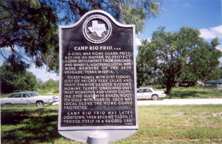
Marker Title: | Camp Rio Frio, C.S.A. |
| Photo: | Camp Rio Frio Photo Submitted by Renee Smelley | |
| Year Marker Erected: | 1964 | |
| Marker Location: |
On Highway 16 1/2 miles north
of intersection of Highway 16 and Highway 72 (across from Caja Hill), Tilden,
Texas.
|
|
| Marker Text: |
A Civil War home guard post,
acting as buffer to protect older settlements from Apaches and bandits.
Scattered local men were members of the 29th Brigade, Texas Militia. Picket
homes with dirt floors. Diet of prickly pear salad and fruit, Spanish dagger
blooms, hominy, turkey, quail and deer meat. Homespun and linsey clothing
dyed blue with Brazil root or gold with agarita. Such was local scene the
home guard protected. Camp Rio Frio was later Dogtown, then became Tilden.
It proved itself in a rugged era. (1964)
|
|
|
Marker Title: | Louisa Renshaw Covey |
| Photos: | Historical Marker Courtesy of Carmen Ream | |
| Year Marker Erected: | 1969 | |
| Marker Location: |
Located in Hilltop Cemetery;
take local road off of Highway 16 two blocks south of intersection with
Highway 72. Follow road to top of hill to cemetery, Tilden.
|
|
| Marker Text: |
Born in Philadelphia; married
Dr. J.V.E. Covey, Baptist minister and teacher, in 1845. They came to Texas
during the 1850's as missionary-teachers. Regarded by her associates as
a gifted instructor, Mrs. Covey aided her husband in founding and operating
three colleges. In 1857 they established Alma Institute at Hallettsville;
then during the Civil War, Concrete College near Cuero; an in 1881, McMullen
College at Tilden. Recorded -- 1969
|
|
| Links of Interest: | McMullen
College - Handbook of Texas Online
Concrete College - Handbook of Texas Online Alma Institute - Handbook of Texas Online |
|
|
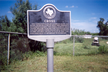
Marker Title: | Cross, Texas |
|
|
Photos: | Historical
Marker | Cross
Bar-B-Q Store submitted by Renee Smelley
The Cross Bar-B-Q Store is no longer in operation. |
| Year Marker Erected: | 1967 | |
| Marker Location: |
From Tilden, take Highway
16 about 5 miles north to Marker on Highway 16 R.O.W.
|
|
| Marker Text: |
This community (earlier known
as Nopal, San Miguel, Franklin) is one of area's first permanent settlements.
Named for Samuel C. Cross, who opened grocery store, became first postmaster,
1924. Post office closed, 1934. Gas well completed nearby, 1953, was largest
in state at that time. Ranching also is important to economy. (1967)
|
|
| Links ofInterest: | Cross, TX - Handbook of Texas Online |
|
|
Marker Title: | Site of Old Crowther Ranch |
| County: | McMullen | |
| Year Marker Erected: | 1968 | |
| Marker Location: |
From Tilden, take Highway
72 east about 8 miles, then take Route 99 East about 10 miles. Marker located
on curve on south side of 99 East. Just before line from McMullen-across
from Ranch driveway.
|
|
| Marker Text: |
Townsite of 1600 acres established
by 1902. Named in honor of Samuel Crowther on whose land it was located.
Purchased by S.A. Hopkins in 1903. Extensive promotion failed to develop
community into oil and farming center despite early oil discoveries. Became
a ghost town by 1921. Bought by George T. Jambers, 1933. (1968)
|
|
| Links ofInterest: | Crowther, TX - Handbook of Texas Online |
|
|
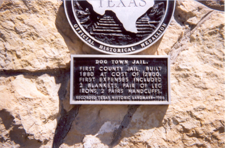
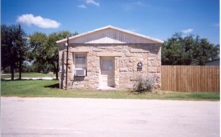
Marker Title: | Dog Town Jail |
|
|
Year Marker Erected: | 1966 |
| Photos: | Historical Marker | Dogtown Jail Photos submitted by Renee Smelley | |
| Designations: | Recorded Texas Historic Landmark | |
| Marker Location: |
Behind courthouse, located
at intersection of Highway 72 and Highway 16, Tilden.
|
|
| Marker Text: |
First County Jail, built 1880
at cost of $2800. First expenses included 2 blankets, pair of leg irons,
2 pairs handcuffs. Recorded Texas Historic Landmark, 1966.
|
|
|
Marker Title: | Moses William Hindes |
| Photo: | Historical Marker submitted by Renee Smelley | |
| Year Marker Erected: | 1968 | |
| Marker Location: |
Located in Boot Hill Cemetery
across from town square on Route 72, one block east of intersection of
Highway 72 and Highway 16, Tilden.
|
|
| Marker Text: |
A pioneer in settling of southwest
Texas. Born in South Carolina; married Mary Jane Mason. Moved in 1840's
to Alabama, then to Mississippi. With wife and 6 children came in 1855
by ox-wagon and horse-drawn hack to Texas. After a year in Lockhart, moved
(1856) to this area of sparse settlements. To have adequate water for cattle
raising, tried living on Ash and San Miguel Creeks. Then settled on the
Frio, where in drouths "wells" were sunk in the river bed. During the Civil
War (1861-1865) Hindes and his son George were Confederate scouts. In that
time Indians plundered this area, stealing children and horses. On Aug.
1, 1865, warning came of a new Indian raid. Neighbors went to Hindes' home
(9 mi. sw) for safety. 6 men took turns guarding 40 horses held in the
corral. At daybreak when the Indians attacked, Moses Hindes was shot to
death defending his homestead. Buried at first in this Boothill, he was
later reburied in Pleasanton Cemetery, Atascosa County. His heirs remain
loyal to this area for which Mr. Hindes died. George, the eldest son, founded
the town of Hindes, Atascosa County. The Hindes & Beever Store, Pearsall,
sold first pearburner ever marketed. Every generation has had men who rode
with Texas Rangers. 1968 Incise in base: Erected by great-grandchildren,
Carrie Hindes Eppright and Leroy Hindes.
|
|
| Links of Interest: |
|
|
Marker Title: | Loma Alta |
| Year Marker Erected: | 1973 | |
| Marker Location: |
From Tilden, take Highway
16 South about 23 miles, turn east onto Route 624 and follow about 3.5
miles east to Marker.
|
|
| Marker Text: |
First settlers moved into
region in early 1880s. Community was named for Loma Alta/Hills. School,
built 1896, moved several times in area until consolidation, 1943. Post
office, established Jan. 3, 1910, was discontinued April 15, 1921. School
and post office served large area of this ranching country. 1973
|
|
| Links of Interest | Loma Alta, TX - Handbook of Texas Online |
|
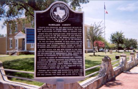
Marker Title: | McMullen County |
| Photo: | Historical Marker submitted by Renee Smelley | |
| Year Marker Erected: | 1964 | |
| Marker Location: | In front of courthouse on corner of Highway 16 and Highway 72, Tilden. | |
| Marker Text: |
Created 1858. Organized 1862.
Abandoned because of bandit activities in thicket area during the Civil
War. Reorganized 1877, with Tilden as county seat. Named for John McMullen
(1785-1853), founded with James McGloin of the Irish Colony at San Patricio;
President Pro Tempore of the General Council which governed Texas in 1836,
on the eve of the Republic. Of the 254 Texas counties, 42 bear Indian,
French or Spanish names. 10 commemorate such colonizers as McMullen and
Stephen F. Austin, "Father of Texas". 12 honor Washington and other American
patriots. 96 were named for men who fought in the Texas war for independence
(15 dying at the Alamo), signed the Declaration of Independence from Mexico,
or served as statesmen in the Republic of Texas. 23 have the names of frontiersmen
and pioneers. 11 honor American statesmen who worked for the annexation
of Texas; 10, leaders in Texas since statehood, including jurists, ministers,
educators, historians, statesmen; and 36, men prominent in the Confederacy
during the Civil War. Rockwall and 8 others have geographical names. San
Jacinto and Val Verde were named for battles; Live Oak and Orange, for
trees; and Mason for a fort. 1964
|
|
|
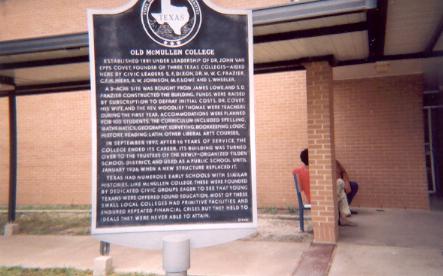
Marker Title: | Old McMullen College |
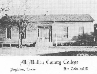
|
Photo: | Historical
Marker submitted by Renee Smelley
McMullen College Postcard submitted by Beth Walker |
| Year Marker Erected: | 1967 | |
| Marker Location: |
On Highway 16, 2-3 blocks
south of intersection of Highway 16 with Highway 72. Located in front yard
of elementary school, Tilden.
|
|
| Marker Text: |
Established 1881 under leadership
of Dr. John Van Epps Covey, founder of three Texas colleges--aided here
by civic leaders S.F. Dixon, Dr. M.W.C. Frazier, C.F.H. Hiers, R.W. Johnson,
M.F. Lowe and L. Wheeler. A 3-acre site was bought from James Lowe, and
S.D. Frazier constructed the building. Funds were raised by subscription
to defray initial costs. Dr. Covey, his wife, and the Rev. Woodlief Thomas
were teachers during the first year. Accommodations were planned for 100
students. The curriculum included spelling, mathematics, geography, surveying,
bookkeeping, logic, history, reading, Latin, other liberal arts courses.
In September 1897, after 16 years of service, the college ended its career.
Its building was turned over to the trustees of the newly-organized Tilden
School District, and used as a public school until January 1926, when a
new structure replaced it. Texas had numerous early schools with similar
histories. Like McMullen College, these were founded by dedicated civic
groups eager to see that young Texans were offered sound education. Most
of these small local colleges had primitive facilities and endured repeated
financial crises, but they held to ideals they were never able to attain.
1967
|
|
| Links of Interest | McMullen College - Handbook of Texas Online |
|
|
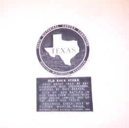
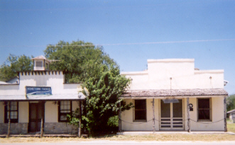
Marker Title: | Old Rock Store |
|
|
Photos: | Old Rock Store Historical Marker | Old Rock Store Photos submitted by Renee Smelley |
| Year Marker Erected: | 1966 | |
| Designations: | Recorded Texas Historic Landmark | |
| Marker Location: |
Faces courthouse across from
courthouse on Route 16 at intersection with Highway 72, Tilden.
|
|
| Marker Text: |
Built about 1865 by Pat Cavanaugh,
Irish stonemason, assisted by Dick Barker. Site of gun battles in Dog Town
(now Tilden), "wide open" during lawless era of the 1860's and 1870's.
Preserved since 1929 by Clifton Wheeler, owner. Recorded Texas Historic
Lankmark, 1966.
|
|
| Links of Interest: | McMullen County Historical Museum and Archives |
|
|
Marker Title: | Old San Antonio-Laredo Road |
|
|
Photos: | San Antonio Laredo Road | Marker Text Photos submitted by Renee Smelley |
| Year Marker Erected: | 1973 | |
| Marker Location: |
Highway 72 about 5 miles west
of Tilden, Texas
|
|
| Marker Text: |
Shortly after the founding
of Laredo, in 1755, the Spanish established a transportation-communication
route across this site. The road provided necessary abundance of
water and grass for travel across the arid region, and served as a vital
link between San Antonio and Laredo for well over a century. Although
under constant surveillance by hostile Indian tribes, this route was traversed
by numerous notable people. Fray Gaspar Jose De Solis passed this
site on Aug. 21, 1868, on return from an inspection of Spanish Texas Mssions.
Stephen F. Austin, en route to Mexico City to seek a colonization grant,
crossed here about March 18, 1822. On Feb. 26, 1828, Manuel De Mier
Y Teran passed on his way to survey Anglo-American strength in Mexican
Texas. The Somervell Expedition, in punitive retaliation for a Mexican
invasion of Texas, crossed here on Dec. 1, 1842, bound for Laredo.
Before and after the Civil War the road was used as a military supply route
from San Antonio to Forts Ewell (1852-1854), at Nueces River Crossing,
and McIntosh, at Laredo, and as a trade outlet for early settlers.
Although abandoned after ranches were fenced and a railroad from San Antonio
to Laredo was built in 1881, the road is still visible on the open range.
(1973)
|
|
|
Marker Title: | San Caja Hill |
| Photos: | Historical Marker | Historical Marker Text photos submitted by Renee Smelley | |
| Year Marker Erected: | 1968 | |
| Marker Location: |
Highway 16 just .5 miles north
of Wheeler Store on west side of road before bridge, Tilden.
|
|
| Marker Text: |
The name, originally "Sin
Caja", means "without coffin" in Spanish and may refer to the grim aftermath
of the Turkey Creek Indian Battle, which was fought a short distance west
of the hill in December 1872. The fight developed after raiding Indians
had stolen livestock, chased young rancher Andrew Tullis, and dragged a
herder to death at the J. Campbell place. The day following the killing,
13 ranchers from Oakville overtook the band at Turkey (now "Hill") Creek.
Five Indians were slain, while one white man, Sebastian Beall, had a tooth
shot out. Others in the fight were Caleb Coker, Tim Cude, John Edwards,
Bob and Sam Nations, Tobe Odom, Cullen Sanders, Andrew and Woodie Tullis,
Rans Tullos, Pleas Waller, John Wilson. The bones of the warriors, put
in a cave in San Caja Hill, later mysteriously disappeared. They were supposedly
removed by members of the same tribe. Legends of treasure also hinge upon
the name of the hill, for "Caja" can mean "box" or "chest." This is thought
to refer to money hidden in boxes here by Mexican bandits who raided wagon
trains and stages traveling on the nearby Laredo-Goliad Road. Other tales
tell of silver from the rich San Saba mines once buried nearby, but now
lost to history. 1968
|
|
| Links of Interest: | San Caja Hill - Handbook of Texas Online |
|
|
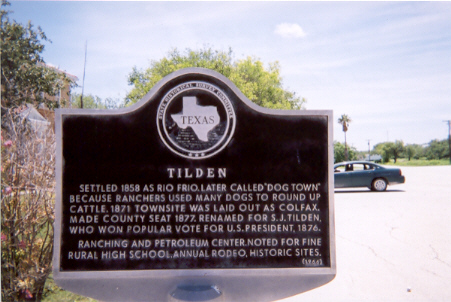
Marker Title: | Tilden, Texas |
| Photo: | Tilden Historical Marker Photo submitted by Renee Smelley | |
| Year Marker Erected: | 1966 | |
| Marker Location: | At intersection of Highway 16 and Highway 72 in front of Courthouse, Tilden. | |
| Marker Text: |
Settled 1858 as Rio Frio.
Later called "Dog Town" because ranchers used many dogs to round up cattle.
1871 townsite was laid out as Colfax. Made county seat 1877. Renamed for
S.J. Tilden, who won popular vote for U.S. President, 1876. Ranching and
petroleum center. Noted for fine rural high school, annual rodeo, historic
sites. 1966
|
|
| Links of Interest: | McMullen County Courthouse Past and Present |
|
|
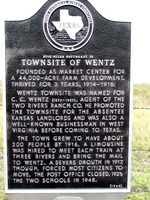
Marker Title: | Townsite of Wentz |
| Photos: | Historical Marker submitted by Michael Tope | |
| Year Marker Erected: | 1968 | |
| Marker Location: |
(In roadside turnaround with
Yarbrough Bend Marker), from Tilden, take Highway 72 East about 6 miles
to markers.
|
|
| Marker Text: |
Founded as market center for
a 44,000-acre farm development. Thrived for 3 years, 1914-1916. Wentz townsite
was named for C.C. Wentz (1872-1957), agent of the Two Rivers Ranch Company.
He promoted the townsite for the absentee Kansas landlords, and was also
a well-known businessman in West Virginia before coming to Texas. The town
grew to have about 200 people by 1916. A limousine was hired to meet each
train at Three Rivers and bring the mail to Wentz. A severe drouth in 1917,
though, forced most citizens to move. The post office closed, 1921; the
two schools in 1948. 1968
|
|
| Links of Interest: | Wentz, TX - Handbook of Texas Online |
|
|
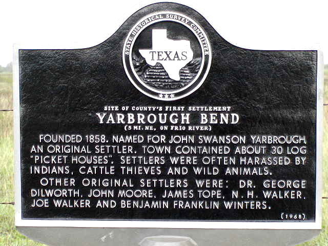
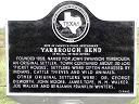
Marker Title: | Yarbrough Bend |
| Photos: | Historical Marker submitted by Michael Tope Panaramic View of Marker - Submitted by Renee Smelley | |
| Year Marker Erected: | 1968 | |
| Marker Location: |
(With Townsite of Wentz Marker),
from Tilden, take Highway 72 six miles east to road side marker.
|
|
| Marker Text: |
Founded 1858. Named for John
Swanson Yarbrough, an original settler. Town contained about 30 log "picket
houses". Settlers were often harassed by Indians, cattle thieves and wild
animals. Other original settlers were: Dr. George Dilworth, John Moore,
James Tope, N.H. Walker, Joe Walker and Benjamin Franklin Winters. 1968
|
|
| Links of Interest: | John Swanson Yarbrough Archives - Site includes: Yarbrough, Moore, Tope, Walker & Winters surnames. |
|
|
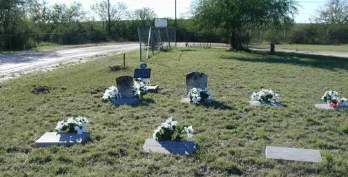
Marker Title: | John Swanson Yarbrough |
| Photos: | Historical Marker | White Poinsettias were planted at the Yarbrough Cemetery graves by Jan Hinds on December 19, 2001 a GR GR GR Granddaughter of John Swanson Yarbrough. The marker dedication took place on December 8, 2001 at the Courthouse in Tilden. Photos submitted by Beth Walker. | |
| Year Marker Erected: | 2001 | |
| Marker Location: | in Hill Top Cemetery, 0.8 mile east of SH 16 on Hackberry St./Cemetery Rd., Tilden | |
| Marker Size: | Grave Marker | |
| Marker Text: | (Dec. 25, 1774 - Oct. 20, 1862) A native of North Carolina, John Swanson Yarbrough came to Texas in 1832 and settled in what is now Houston County in east Texas. A veteran of the Texas War for Independence, Yarbrough participated in the 1835 Siege of Bexar and in the decisive Battle of San Jacinto. He moved from Houston County about 1850 and led a group of settlers to the Frio River in 1858 to establish the Yarbrough Bend settlement in what became McMullen County. Yarbrough's grave was relocated to this site from the Yarbrough Bend Cemetery in 1982 as part of the construction of Choke Canyon Reservoir. Recorded - 2001 | |
| Links: | Hill Top Cemetery in Tilden, Texas |
|
|
Marker Title: | Townsite
of Zella
|
| Year Marker Erected: | 1968 | |
| Marker Location: |
From Tilden, take Highway
72 west about 15 miles, make a right onto 92 and go north/east about 6
miles to Zella townsite (on left just over cattle guard) just before Franklin
Ranch Road.
|
|
| Marker Text: |
Organized 1913, with 189 city
blocks laid off along San Antonio, Uvalde & Gulf Railroad. Structures
built included depot, store-post office, schoolhouse, hotel. A water well
was drilled. War and the 1917 drouth stifled growth. Few lots were sold;
land ownership was retained by founders. 1968 Incise on back: Founders
were C. A. Nelson, Howard Bland and R. B. Pumphrey, owners of Zella Townsite
Company.
|
|
| Links of Interest: | Zella, TX - Handbook of Texas Online |
|
This site is a genealogy website and is a part of the TXGenWeb Project. |
Materials on this site are provided for the free use of persons who are researching county history or family history. Data may be freely used by non-commercial and/or completely free entities, as long as this message remains on all copied material. Any commercial use, without prior consent of the host/author of the materials provided on this site, is prohibited. The electronic pages on this site may not be reproduced in any format for profit.
Notice to Webmasters: You may not copy and paste the information on any of the pages of this site onto another web page without first obtaining explicit permission to do so and without including the copyright notice.
Disclaimer: "Links to sites that are not part of the USGenWeb Project are provided for your convenience and do _not_ imply any endorsement of the sites or their contents by the USGenWeb Project or its members. Neither the USGenWeb Project nor its members are responsible for the contents of any "third party" site which you may access from a link on the McMullen County TXGenWeb Project."


