| 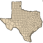 Wheeler County is on the eastern edge of the Panhandle of Texas, along the Oklahoma border. Wheeler, the county seat, is three miles northwest of the center of the county and 100 miles east of Amarillo. The area was named for Royal T. Wheeler, the second chief justice of the Texas Supreme Court. Wheeler County occupies 914 square miles of rolling prairies and rough river breaks in the area east of the High Plains; elevations range from 2,000 to 2,800 feet above sea level. The red sandy loam and black clay soils produce abundant native grasses as well as wheat, sorghums, cotton, and alfalfa. Cottonwood, black walnut, chinaberry, willow, hackberry, mesquite, and shin oak trees are found along river and creek bottoms and in other watered areas in the county. The North Fork of the Red River and Sweetwater Creek are the two major streams in the county. Numerous lesser streams drain into them, contributing to the rough nature of the terrain. The average annual rainfall is 23.7 inches. Temperatures range from an average minimum of 26° F in January to an average maximum of 97° F in July. The average growing season lasts 208 days. Mineral resources include caliche's, gypsum, petroleum, and natural gas. Taken from the Handbook of Texas On Line . Wheeler County is on the eastern edge of the Panhandle of Texas, along the Oklahoma border. Wheeler, the county seat, is three miles northwest of the center of the county and 100 miles east of Amarillo. The area was named for Royal T. Wheeler, the second chief justice of the Texas Supreme Court. Wheeler County occupies 914 square miles of rolling prairies and rough river breaks in the area east of the High Plains; elevations range from 2,000 to 2,800 feet above sea level. The red sandy loam and black clay soils produce abundant native grasses as well as wheat, sorghums, cotton, and alfalfa. Cottonwood, black walnut, chinaberry, willow, hackberry, mesquite, and shin oak trees are found along river and creek bottoms and in other watered areas in the county. The North Fork of the Red River and Sweetwater Creek are the two major streams in the county. Numerous lesser streams drain into them, contributing to the rough nature of the terrain. The average annual rainfall is 23.7 inches. Temperatures range from an average minimum of 26° F in January to an average maximum of 97° F in July. The average growing season lasts 208 days. Mineral resources include caliche's, gypsum, petroleum, and natural gas. Taken from the Handbook of Texas On Line .
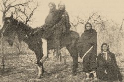 The Texas Panhandle was occupied by a Plains Apache culture, followed by modern Apache people, who in turn were displaced by the Kiowa and Comanche around A.D. 1700. The Kiowa and Comanche dominated the Panhandle until they were finally defeated in the Red River War of 1874. Following their defeat the Indians were removed to reservations located in Indian Territory (Now Oklahoma) during 1875 and 1876. (The photoabove is of a Kiowa Family circa 1890.) The Texas Panhandle was occupied by a Plains Apache culture, followed by modern Apache people, who in turn were displaced by the Kiowa and Comanche around A.D. 1700. The Kiowa and Comanche dominated the Panhandle until they were finally defeated in the Red River War of 1874. Following their defeat the Indians were removed to reservations located in Indian Territory (Now Oklahoma) during 1875 and 1876. (The photoabove is of a Kiowa Family circa 1890.) |
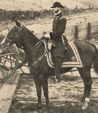 General William Tecumseh Sherman ( Photo below left ) toured the region after the the Civil War ended in order to evaluate the Indian problem. He personally interviewed my great grandmother and her grandmother regarding their ordeal as captives of the Kiowa during the Civil War years as both of them were captured in the Elm Creek raid in Young County in 1863 along with her infant sister and teenaged uncle. The uncle was killed and the sister was never returned. General William Tecumseh Sherman ( Photo below left ) toured the region after the the Civil War ended in order to evaluate the Indian problem. He personally interviewed my great grandmother and her grandmother regarding their ordeal as captives of the Kiowa during the Civil War years as both of them were captured in the Elm Creek raid in Young County in 1863 along with her infant sister and teenaged uncle. The uncle was killed and the sister was never returned.
Following the tour, General Sherman ordered the slaughter of the buffalo herds to limit the food supply of the plains Indians (in the belief that they would be forced into dependency on the government for food and except reservation life). Buffalo hunters began moving into the area before the Indians were removed because the sale of the hides was a lucrative and profitable business. In the spring of 1874 hunters with their massive amounts of buffalo hides began to converge on Sweetwater Creek and a crude outpost, called Hidetown (Later named Mobeetie) was established in what is now the northwestern part of Wheeler County along the Texas and Oklahoma border.
To keep the Indian population on their reservations in Indian Territory, the United States Army established a frontier garrison near Hidetown in June 1875. This outpost was called Fort Elliott and remained operative until 1890, providing both protection and economic benefits for the increasing population of panhandle settlers. As a side business my great grandfather grew fresh produce in his truck garden and sold it to the soldiers at the fort. In 1878 the first Panhandle post office was established there. As the Indian threat subsided in 1875 and 1876, settlers began to congregate around Fort Elliott and Hidetown, and in 1876 the Texas state legislature established Wheeler County from lands formerly assigned to the Bexar and Young districts. |
When buffalo were hunted out of existence, the cattle ranching industry financed by European investors began to emerge in the area and an increasing number of former buffalo hunters, discharged soldiers, and new ranchers were settling in the county. In 1879 the local residents petitioned for county organization. On April 12, 1879, Wheeler County became the first organized county in the Panhandle, with fourteen unorganized counties attached to it.
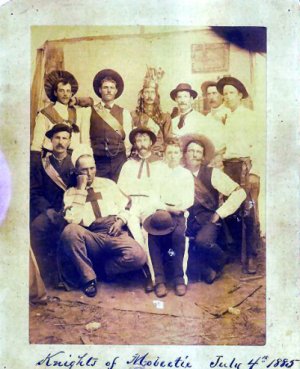 My great grandfather, Dave Barker was one of the early settlers of Mobeetie. He was drawn to the area because of his exceptional skills as a butcher and past history as a lawman. In his time he was well known as a no nonsense constable and deputy sheriff. He lived by the gun and he died by the gun. In the group photo above, he is the last man standing on the right. The identities of those in the photo are as follows: From Left to right top row, Eddie Clampitt, Ellison Carroll, Bert Clampitt, Jack Thompson, Unknown and Dave Barker. Bottom row left to right, Paddy Boyles, Jim Osborn, Matt Lock, Milo Burlingame and Wilson Harrah. (Photo courtesy of the Old Mobeetie Museum). ~ Jim Hewitt My great grandfather, Dave Barker was one of the early settlers of Mobeetie. He was drawn to the area because of his exceptional skills as a butcher and past history as a lawman. In his time he was well known as a no nonsense constable and deputy sheriff. He lived by the gun and he died by the gun. In the group photo above, he is the last man standing on the right. The identities of those in the photo are as follows: From Left to right top row, Eddie Clampitt, Ellison Carroll, Bert Clampitt, Jack Thompson, Unknown and Dave Barker. Bottom row left to right, Paddy Boyles, Jim Osborn, Matt Lock, Milo Burlingame and Wilson Harrah. (Photo courtesy of the Old Mobeetie Museum). ~ Jim Hewitt
|