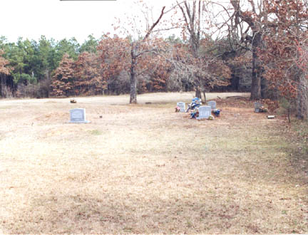
Bryarly
B Cemetery

Bryarly B Cemetery, 19 Aug 1927,"This
cemetery is located in the northeast quadrant of Red River County,
Texas. GPS COORDINATES: Datum WGS84: 33 Deg 44.432N, 94 Deg 54.157W.
This cemetery is in the northeast quarter of RRCo TX just past
Reed's Settlement. From Clarksville take FM 1159 for about 10.5
miles to the intersection with CR 3235. Take CR 3235 east or
right for 1.2 miles to the intersection with CR 3230. Take CR
3230 northeast for 1.3 miles and the cemetery is on the east
or right. There is a release of 6 acres of land from W. E. Bonham
et ux to the Bryarly Chapel Missionary Baptist Church of the
George Peerman survey from a 102 acre tract John Isaac et ux,
instrument made on 21 Oct 1920 and filed for record on 25 Feb
1921 in Book CH Vol 102 Page 449. Another deed dated 13 Sep 1952
and filed for record on 31 Aug 1963 in Book CH Vol 232 Page 481
for 52 acres of R. T. Bryarly survey less 2 acres set aside for
cemetery from Alonzo Smith et ux to Willie Melvin Smith, Sr.
This cemetery is old and has been in use for many years, the
problem is that no permanent markers were erected. From the size,
about three acres of land being mowed, and from the number of
grave depressions in the area, I would put a conservative guess
of from 200 to 300 burials for which there are no records. The
oldest marked burial is that of Earies Dilworth who died on 19
Aug 1927. This cemetery was surveyed by Lawrence and Sue Dale
on 15 Jan 1999. As a spot recheck this cemetery was revisited
on 13 Feb 2000. We visited the site again on 8 Dec 2003 and took
the GPS readings. We also did a re-walk of the cemetery adding
new burials and noting marker changes."
|


