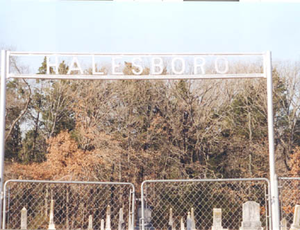
Halesboro
Cemetery

Halesboro Cemetery, 10
Aug 1872,"This cemetery is located in the southwest quadrant
of Red River County, Texas. GPS COORDINATES: Datum WGS84: 33
Deg 27.738N, 95 Deg 18.271W. To reach this cemetery proceed from
Rugby south 3.1 miles to Marris Chapel on FM 410. Turn right
or west on FM 410 and go west about 2.2 miles until FM 410 turns
south. At this point turn right onto CR 1135 and proceed north
for about .8 miles to the intersection with CR 1131, The cemetery
is on the left. The earliest suspect deed transaction we could
find conveys 2 acres of the Joshua C. Hale survey from John D.
Bloodworth et ux to Halesboro Masonic and Church. This instrument
is dated on 9 Jan 1877 and filed for record on 9 May 1898 in
Book CH Vol 34 Page 380. There is a deed transaction dated 9
Feb 1880 conveying 1 acre of land on the Josiah C. Hale survey
filed on 26 Aug 1893 in Book CH Vol 25 Page 574 from Lucinda
Bloodworth to Halesboro Methodist Church. The oldest marked burial
is that of Mary E. Clifton who died on 10 Aug 1872. This cemetery
was surveyed by Lawrence and Sue Dale on a soggy 14 Dec 1998.
After entering all data this was printed and the cemetery walked
a second time on 16 Dec 1998 to correct any possible errors.
This cemetery was revisited on 20 Jan 2003 and took the GPS Coordinates.
We also did a re-walk of the cemetery on 23 Jan 2004 adding new
burials and noting marker changes."
For Inventory Go Here
|

