Ferris’s first attempts at fulfilling his surveying contract with King were made in early September 1839 with fifty-five men and again in late September with forty-four men, but both trips were abruptly ended shortly after leaving Nacogdoches when fresh signs indicated that Indians were near. As early surveyor John Harvey had warned all who ventured into the territory, “When you least expect Indians, there they are.”
In October 1839, Ferris made a third attempt. He organized an expedition with sixty men, divided into companies to watch and guard the surveyors, but on that trip their efforts were repulsed before ever getting out of east Texas. In November Ferris was able to find but twenty-nine men willing to make the trip back to the Three Forks region and after twelve days, near Jordan’s Saline, they came upon Indians hidden and ready to ambush them. The surveying party charged the Indians and drove them away, but not before Ferris killed one. In his memoirs Ferris wrote that the Indian was better armed than he and his men, with an English rifle, a Prussian pistol, a Bowie knife, a butcher knife and bow and arrows. After this encounter, the men of the party, except four, left Ferris and returned home.
One of the four who stayed with Ferris was a man who would be a true friend for the remainder of their lives. John Henninger Reagan (1818 – 1905) of Tennessee was in Texas by early 1839. His life’s accomplishments included being an Indian fighter, Attorney, District Judge, Texas Congressman, Postmaster General of the Confederacy, U.S. Senator and the first Railroad Commissioner in Texas. Reagan, Ferris, and the other three men continued Ferris’ fourth expedition. The weather was cold and wet. Fearing ambush, the little party of five traveled by night and hid during the day. By the time they finally reached Cedar Creek, east of the Trinity, Ferris proclaimed the trip too dangerous to proceed and they returned to Nacogdoches.
As soon as the weather improved in March 1840, Ferris and Reagan made another stab at surveying the land, but heavy rains pushed them back. These numerous failed attempts at getting the surveys completed alarmed King. His Southern Land Company could not do business without surveys for deeds, so in April 1840 King financed Ferris’ next expedition. On June 4, 1840, Ferris left Nacogdoches with a party of twenty-nine men and under the supervision and companionship of William King, who had decided to see the frontier for himself. Their plan was to have three divisions of surveyors, with a crew of additional men to guard the surveyors and to build a fort to serve as a base for the surveying parties.
The collaboration between King and Ferris would produce the first fort in Texas that was not initially requisitioned by any government agency. Construction was started in June 1840 and by August they had built a picketed stockade with a dwelling. Cedar and bois d’arc trees grew abundantly along the creek nearby and offered ample building materials. The pickets were formed of poles only a few inches in diameter and ten feet long, set about two feet in the ground, thus making the walls approximately eight feet high. From descriptions of King’s Fort in 1841, it is known by that time there was a gate of some type and there were four individual huts or cabins within the walls. The fort was located on a high, rounded bluff with a vista of at least 150 degrees to the north, west and south. It overlooked a tributary of the East Fork of the Trinity that lay ¼ mile west of the site. This deep creek, at least 200 feet below the bluff’s crest, was named King’s Creek by the surveyors and provided fresh water for livestock and human needs.
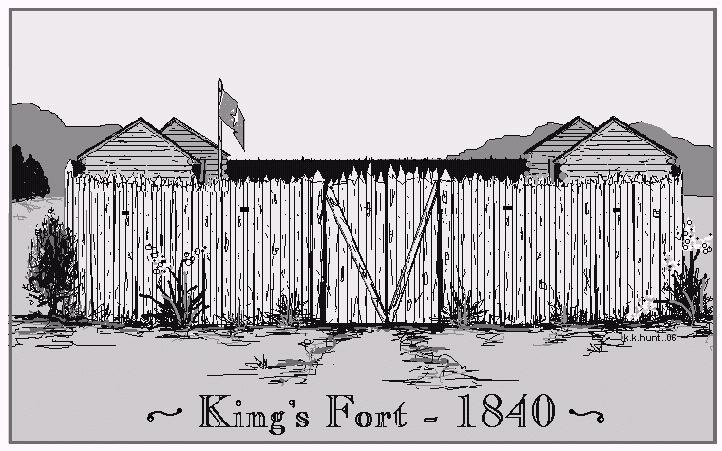
Illustration of how the fort may have looked
Derived from oral descriptions made of the fort
Drawing by K K Hunt
With adequate shelter from the elements and Indians, by the end of 1840 the surveyors had laid off the outlines of the “King Block” of surveys. The 45-degree tilt that King had required continued to be reflected in the lines of future surveys in what is now Hunt, Dallas, Rockwall, Henderson, Van Zandt, and Kaufman counties. Regrettably for Dr. King, however, the majority of the headright certificates held by the Southern Land Company proved to be fraudulent. He did manage to obtain clear title to the survey that included the fort.Throughout the remainder of 1840 and the beginning of 1841, King’s Fort was the center of operations for surveying parties. The strength of the fort and its location appeared to give it immunity from any molestation by the Indians who continued to use the Kickapoo Trace about a mile to the north. However in the summer 1841, the situation changed dramatically.
Waystation To The Frontier
In July 1841, the Republic of Texas launched a two-pronged expedition against the large Indian settlement at Village Creek, now Arlington, Texas. Their intention was to put an end to the increasing number of depredations against white settlers being committed by the Indians. Col. James Smith and the 3rd Brigade of Texas Militia led the southern wing that included men from San Augustine, Nacogdoches, Houston, and Robertson Counties. Their mission was to meet up with the northern wing, Gen. Tarrant’s 4th Brigade from Clarksville and to march against the Indian village. The position of King’s Fort, roughly midway between the northern and southern settlements, and roughly midway between those settlements and the Indian Village, made it a convenient place for the militia to meet prior to their final march against the village.The southern troops rendezvoused at Ft. Houston (near Palestine) and began their advance up the east bank of the Trinity River. An advanced party from Ft. Houston arrived at King's Fort on July 17th. On that same day, Indians attacked the fort. A member of the advance party reported the details of the encounter in the San Augustine Red Lander of August 3, 1841:
| “The fort is composed of four log cabins, picketed round, enclosing about three fourths of an acre, in a poor condition of defense. At 5 o'clock when the men were lying down, the alarm of Indians was heard. We ran for our guns, and on sallying out saw about 25 Indians coming from adjoining wood. They raised the war-whoop, and swept by close to the Fort, on full gallop, driving all our horses with them. We exchanged a few shouts, and killed one of their horses, and wounded some of them. After reconnoitering and making a grand display, they left us in possession of three of their mules, a quiver of arrows, a Comanche saddle, and some skins. They were well-mounted, and had the appearance of Comanches or Ionies.” |
The remainder of the Third Brigade arrived at King’s Fort on the 18th and 19th and awaited the arrival of their commander Col. Smith. On the 20th Smith arrived with troops from Nacogdoches and the entire brigade marched from King’s Fort that afternoon. By July 25th the entire party had arrived at the Indian village, only to discover that Gen. Tarrant’s troops had already driven off the Indians. Smith’s troops destroyed the village and the troops then split, with the original party from Ft. Houston returning there via the west bank of the Trinity, Tarrant’s group returned north towards the Red River, and Smith went back to King’s Fort before venturing back to Nacogdoches.In addition to the Indian’s attack on King’s Fort, another incident occurred in conjunction with Smith’s expedition—the killing of Marshall B. McKeever. McKeever was a citizen of Crockett who had killed Joseph Shanks at Houston County in the spring 1841. In June 1841, McKeever was tried for murder, but a mistrial (probably a hung jury) resulted, and he went free. At some point Marshall McKeever had acquired land in what is now Henderson County, and he was at King’s Fort in late July with the troops of Smith’s Expedition. While encamped at or near King’s Fort, McKeever and a man named James Borroughs had an argument. John Reagan intervened, and he assumed he had put an end to the quarrel. However, Borroughs shot and killed McKeever and fled the scene. While some men set out to detain Borroughs, Reagan buried McKeever near the fort in what would become the first interment of the Kaufman City Cemetery, only ¼ mile from the fort site. Borroughs was eventually captured and brought to trial. Adolphus Sterne of Nacogdoches recorded the result in his diary on May 10, 1842:
| "our District Court in Session-- the case of the Republic vs Borroughs came up for the killing of McKeever of Crockett hard work to get a jury-- at 1 P.M. got a jury, -- the jury retired at 8 1/2 P.M. returned at10 P.M. verdict not guilty, a thing most devoutly hoped for by every one." |
Many years later, in 1890, Reagan returned to Kaufman and sought the assistance of Judge J. E. Dillard to locate the grave of McKeever. The following newspaper article detailed the story:
Terrell Times Star --- Mar 02, 1894
"While digging little Lucian Walker's grave, gravediggers unearthed the body of a man long dead. This is believed to be the man that John H Reagan buried in the early 1840's while he was part of a surveying party. The man died and Reagan and the other men in the party buried him where the Kaufman City Cemetery is now. Reagan told sources the man was buried at the crest of a hill overlooking King's Creek. In 1890 Reagan returned to Kaufman to place a grave marker on the man's grave, but when he went back to the site he was not able to recognize where the man had been buried more than 50 years prior."
|
Two years after the military expedition against the Indian villages, Sam Houston, then President the Republic of Texas, arranged to have a large gathering of Indian leaders at the old villages to negotiate peace. President Houston passed through King’s Fort in July 1843 on his way to the treaty negotiations with the Indians. Houston was in the party of about thirty men, including Englishman Edward Parkinson, who wrote an account of the trip. Parkinson described in his diary the difficulties and trials encountered by the expedition, explaining how the men had to hack their way through groves of Bois d'arc trees in the Trinity River bottoms west of King’s Fort. With the successful completion of the treaty with the Indians, the need for a fortified position east of the Trinity River was much reduced, and the settlement that Dr. William P. King had planned could go forward. However, King himself would not live to see it. On a trip back to Mississippi to gather settlers for his colony, King caught yellow fever and died in Vicksburg on Sept. 16, 1841.
From King’s Fort to Kingsborough to Kaufman
Beginning with a trickle in 1843 and increasing as the years went on, settlers came to the King’s Fort area, which was being called Kingsborough, that grew up around the fort. It is not known exactly how many persons settled at Kingsborough between 1843 and 1846, but based on genealogical records giving birth dates of children born those years, the number is probably as many as one hundred or more.One of these early settlers had indeed been at King’s Fort at its beginning in June 1840, and according to his memoirs, he was the man who shot the Indian’s horse in the forehead during the July 1841 raid. This was Robert Adams Terrell (1820 – 1881), the man for whom Terrell, Texas was named in 1873, and brother of William King’s business partner George Whitfield Terrell. He was a surveyor with Ferris in 1840 and 1841, and was one of the first white men to live in what became Kaufman County. Settlement in the area gradually continued, mostly around the fort and to the southeast. Terrell noted that prior to l844 there were only six or seven families in present Kaufman County, and that during l845 and l846 a good many families settled east of the Trinity River in what was called Mercers Colony. Terrell’s work as a surveyor for King and Ferris often resurfaced later in his life as he was frequently called to testify about the surveys when the legitimacy of the deeds were challenged in court. In 1845 the first known sermon was preached in Kingsborough by Rev. William Kinney Wilson, a Methodist minister. In his memoirs he wrote:
| “In 1845, I was appointed to the Fort Houston circuit as junior preacher, with Rev. M.H. Jones in charge. I remained on this work until July, when the Presiding Elder sent me to what was then called the Kings Borow Country to form a new mission. On the way to this work it was necessary to spend one night in the solitudes of the forest. The distances being so great between Settlements that it could not be traveled in a day. I was then in fact the pioneer preacher. I reached the Settlement on four-mile prairie, preached and formed a small class; from thence I crossed Cedar Creek without roads for fords a distance of six miles to one Mr. Wards, left an appointment then crossed Kings Creek winding my way through the tangled grass a distance of ten miles, which brought me to the house of one Mr. Dameron. Near by was a little log School House the first of the kind ever erected in all this country; then we fixed a stated appointment. From that place I went to Kings Fort, where a small congregation was gathered in a short time for preaching.”
|
Another early Kaufman County pioneer who was at King’s Fort in 1846 was James Smith LaRoe (1801 – 1854). A New Jersey native who made a trek to Texas via ship from New York to New Orleans, then by steamer from there to Shreveport and overland on foot into Texas and back again. His goal in traveling to Texas was to find and acquire land for his family, and when he saw the Three Forks region, decided on three parcels.
* LaRoe actually stayed with the earliest known Rockwall County frontiers-folk & settlers, the Newell family, while on his journey. He wrote of the fort in his diary:
| “[Dec] 20th [1846]:-- In the morning started on and got in the branch and Charlie Sanders got stuck. Had to unhitch in the water and wade almost up to his armpits and could not get his empty wagon out. Had to go 2 miles to get oxen to draw out the wagon. We then put up at Mr. Aglens where we had plenty of everything good. He had a good place called King’s Burrow where the fort was built to fight the Indians.”
|
When Kaufman County was created in 1848, the widow of William P. King, Mrs. Frances Moore Tabor donated a 150 acre tract adjacent to the old Fort for the county seat. Although it required a number of elections and a special act of the legislature, Kingsborough was chosen the county seat. In winning the county seat, Kingsborough lost its name. By law the county seat was renamed Kaufman. The last known contemporaneous reference to King’s Fort is made in the February 9, 1863 Kaufman County Commissioner’s Court Minutes , where it is mentioned as a landmark by County Commissioners in laying out a road. However, half a century after its construction, the ruins of the old fort were still known to children in Kaufman in the 1890’s. William Kelley was born 1888 in Kaufman and grew up there. He left his family a journal of his memoirs which include being at the fort as a boy on many occasions and playing there with a vivid imagination:
 William Lanier Kelley - 1891
Born & Raised in Kaufman
His story of playing at King's Fort as a Boy is below
| “The six blocks from the house to old Kings Fort could be ran by me in five minutes.
With my pals Foster, Nash and the Bryan boys we played Pioneers and Indians, using handmade bows and arrows, tommiehawks and muskets. Some days it seemed the Indians were still there and there was more than one time when we ran back home scared by unexplainable sounds or something moving in the bushes. The landing at
the old fort had a view so wide the train could be seen coming into town and we would run the half mile to beat it to the depot to see who was getting off. On nights when fireworks were shot off in Dallas at the state Fair we would go to the old fort to watch
because we could see the show from there.” |
In 1970 the State of Texas commemorated the site of King’s Fort with a Historical Marker which was updated in 1997. The marker is located at the corner of North Clay Street and FM 987 in Kaufman, and the text is:
| King’s Fort
An early frontier fort of the Republic of Texas, King's Fort was built in June
of 1840 by a survey party led by Warren A. Ferris, then Nacogdoches County
surveyor. Dr. William P. King of Mississippi financed the expedition and
accompanied Ferris. Because the fort was located on a favorite hunting ground
for area Indians, settlement was delayed several years by fear of attacks. The
fort, with its four cabins and a stockade, was used primarily as a way station
and place of refuge for travelers. William King continued his efforts to lure
settlers to the area, buying area land until shortly before his death in 1841.
When Charles F. Mercer's colonists began to arrive in the vicinity between
1844 and 1846, King's Fort became the center of a dispersed community known
as Kingsborough. Kaufman County was formed in 1848. The town lost its bid to
be the county seat then and in 1850, but won a crucial election in 1851. The name
of Kingsborough was changed to Kaufman according to state law. Though her
legal claim to the title was disputed, King's widow, Frances Tabor, is credited
with the donation of 150 acres of the Kingsborough tract to the county seat
for a townsite. (1997)
|
As a fortified outpost on what was then the extreme limit of white settlement in north-central Texas, King’s Fort provided security to surveyors and settlers. It was an important point from which expeditions against the Indians to the west were launched. And as the frontier moved west, it was a waystation for westward travelers. After its brief military career, King’s Fort became the nucleus of Kingsborough and later of Kaufman. Perhaps the true measure of the success of King’s Fort is that in the span of a little more than one generation it would go from a fort defended by armed men against real Indians to a playground for boys to fight imaginary foes.
This was the beginning of Rockwall County's civilization
See "Rockwall County Pioneers" to continue the History
Bibliography:
i Archie P. McDonald, ed., “Hurrah for Texas: the Diary of Adolphus Sterne” ( Austin, TX: Eakin Press, 1986)
ii Probate Records of William P. King, Originals at San Augustine County, TX, Transcripts in the Homer DeGolyer
Collection, Southern Methodist University Library.
iii Susanne Starling, “Land is the Cry” (Texas State Historical Association, Austin, TX – 1998)
iv J.W. Wilbarger “Indian Depredations in Texas” (Austin: Hutchings, 1889; rpt., Austin: State House, 1985).
v Walter Flavius McCaleb “John H. Reagan”, Southwestern Historical Quarterly, Vol. 9 No. 1
From the Houston Telegraph and Texas Register - 1 Sept. 1841
vi 2007 - McKeever’s grave remains unmarked except for a piece of limestone & a small Texas flag.
vii Sketch of a Trip to the Wilderness and Forks of the Trinity River, Edward Parkinson's Diary. Typescript from the Dallas
Historical Society
viii “Early Methodism in Northeastern Texas” by Rev. William Kinney Wilson (Manuscript in a ledger belonging to W.C. Young,
now in the Fondren Library, Southern Methodist University, Dallas, Texas.)
ix Diary of James S LaRoe 17 Oct 1846 - 21 Jan 1847 - Copy of original diary in possession of Kathey K Hunt, Kaufman,
Texas
x Horace P. Flatt, “A Part of the Lord's Big Garden, Kaufman County: Its Early Years” (Dallas: Taylor Publishing
Co,1997)
xi Kaufman County Commissioner’s Court Minutes- Feb 19, 1863 - Book 1, page 154
xii The Journal of William Lanier Kelley (1888-1968 ) includes Memoirs of his childhood in Kaufman Texas – original
manuscript in possession of Kathey Kelley Hunt, his granddaughter
* and Justin Sanders are Kaufman County researchers, genealogists and historians. Their work as individuals and collaborators can be found on the Kaufman County TXGenWeb Project website at http://www.rootsweb.com/~txkaufma/
Text & Illustrations
Copyright 2007
Return to Rockwall County Website
This site is part of the TXGenWeb project and maintained by Jeff Lowe. Content of this site has
been gathered from many sources and transcribed records.
Therefore, errors may occur. When in doubt as to the accuracy of
data contained herein, go to the actual records yourself.
If you find any inaccurate data, please let me know. The
information contained in this website is for your personal use
only. All pages, compilations, transcriptions, graphics, photos and abstracts
are protected by copyright law and may not be published in whole
or in part without written consent of the author, contributor
and/or webmaster.
© Copyright 1996-2023 Rockwall County Coordinators for the TXGenWeb Project, All rights reserved. Contents my be used with electronic or written permission only.
|
|