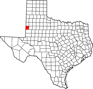
Bronco , TX
USGenWeb >> TXGenWeb >> Yoakum County >> Towns & Communities >> Bronco, Texas
 |
|
| Latitude | 331525N 33.2570508 |
| Longitude | 1030333W -103.0591102 |
| Elevation feet/meters |
3789/1155 |
| Zip Code | |
| Founded | |
| GNIS FID | 1352927 |
| TXGenWeb Site | |
| Cemeteries | |
| Library | |
| Local Genealogy Society | |
| Wikipedia | |
| Texas Escapes | |
|
Highway 380 On the New Mexico state line 14 miles W of Plains 70 miles SW of Lubbock |
|
Bronco never had a railroad, but has somehow managed to reach its centennial year - due to occur in 2003. A cowboy with the colorful name of "Gravy" Fields opened a store and applied for a post office in 1903. The name is said to have been suggested by a traveling salesman.
Field's store supplied ranches in the vicinity and by 1912 the town had 25 persons. The population high-water mark wasn't reached until the 1960s when it was estimated to be 180. It has since declined to the present estimate of 30.
Bronco is on U.S. Highway 380 and the New Mexico border, seventy miles southwest of Lubbock in western Yoakum County. Just two miles west of the town lies old Pueblo Springs, a watering place for Indians before Europeans came to the plains. Sulphur Draw, the headwaters of the Colorado River, originates near Bronco. In 1903 a cowpuncher, H. (Gravy) Fields, started a store at the site of the town. He succeeded in procuring a post office, but because the postal authorities rejected his first choice of a name the town remained nameless until some months later, when a traveling salesman suggested Bronco after seeing a local cowboy ride a bucking horse. K. T. Manning served as the first postmaster. By 1912 Bronco had a population of twenty-five and a store that served surrounding ranches. In 1915 L. W. Walker had established a flour mill there. A cotton gin was built at the town in 1947. Bronco's growth, like that of other Yoakum County towns, was hindered by the lack of a railroad. The reported population peaked in 1961 at an estimated 180, then by the mid-1960s fell to thirty, where it remained in 2000.
Leoti A. Bennett
BIBLIOGRAPHY: Frank P. Hill, "Plains Names," Panhandle-Plains Historical Review 10 (1937). Texas Industrial Commission, General Community Profile on Plains (Austin, 1976). Texas State Highway Department, A Guide to the South Plains of Texas (Lubbock, 1935).
Handbook of Texas Online, Leoti A. Bennett, "BRONCO, TX"


