


Hemphill County Historical
Markers
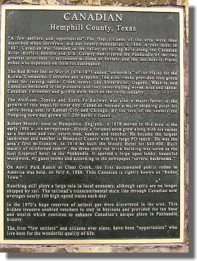
Anvil Park Ranch, Canadian
Marker Location: from Canadian drive U.S. 60, north about 2 miles to
junction with S.H. 2266, turn right on 2266, marker is about 3.5
miles east
Year Marker Erected: 1967
Marker Text: Begun 1891 by blacksmith J. C. Studer who came from
Kansas in 1886. His occupation inspired Anvil brand and name of
ranch. Ran only purebred cattle after 1919. Drew top cattle buyers.
Spread grew from two sections to 5,000 acres. Famous for annual
professional rodeo 1918 to 1941. Attracted top cowboys from
throughout nation. Many stars of rodeo world started here. As many
as 8,000 visitors viewed 3-day performances. Ranch was sold 1951 to
Texas Parks & Wildlife Commission for game breeding purposes.
Recorded Texas Historic Landmark, 1967.
Buffalo Wallow Battle Ground, Canadian
Marker Location: from Canadian, travel south on U.S. 83,
approximately 15.5 miles, turn left onto S.H. 277, continue
approximately 7 miles to dirt road, take right turn, continue about
1 mile to marker
Year Marker Erected: 1925
Marker Text: Here on September 12th, 1874, two scouts and four
soldiers defeated 125 Kiowa and Comanche Indians. Scouts: William
Dixon, Amos Chapman Soldiers: Sergeant Z. T. Woodall, Co. I; Peter
Rath, Co. A; John Harrington, Co.H; George W. Smith, Co. M, 6th
Cavalry. Stand Silent: Heroes here have been who cleared the way for
other men. Erected by Panhandle-Plains Historical Society, September
12th, 1925. This site marked under direction of J. J. Long,
Mobeetie, Texas. Mrs. William Dixon, Miami, Texas. (1966)
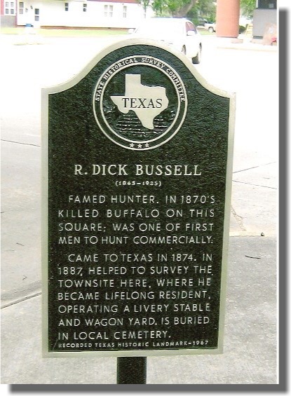
Bussell, R. Dick
Marker Location: at Courthouse, Main & 5th Street, Canadian
Year Marker Erected: 1967
Marker Text: (1845-1935) Famed hunter, in 1870s killed buffalo on
this square; was one of the first men to hunt commercially. Came to
Texas in 1874. In 1887, helped to survey the townsite here, where he
became lifelong resident, operating a livery stable and wagon yard.
Is buried in local cemetery. Recorded Texas Historic Landmark, 1967.
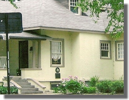
Canadian Hospital, The Former, Canadian
Marker Location: at intersection of 7th & Elsie Street, Canadian
Year Marker Erected: 1970
Marker Text: This building, now a residence, was Canadian's first
hospital, opened on June 16, 1917. Funds for construction were
obtained by public subscriptions. Dr. H. C. Caylor, first owner,
sold to Dr. L. V. Dawson in 1920. From 1924 to 1949, Dr. E. H.
Morris was owner. A tornado that killed or hurt some 200 to 260
people in the Glazier-Higgins area (10 to 27 miles northeast) on
April 9, 1947, dramatized worth of this hospital - the only one in
the immediate vicinity. It was closed in 1949. Recorded Texas
Historical Landmark, 1970.
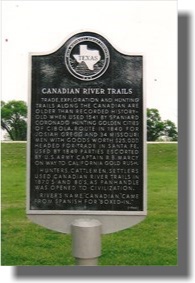
Canadian River Trail, Canadian
Marker Location: from Canadian, travel on U.S. 60/83 1 mile north,
marker is in roadside park
Year Marker Erected: 1966
Marker Text: Trade, exploration and hunting trails along the
Canadian are older than recorded history -old when used 1541 by
Spaniard Coronado hunting golden cities of Cibola. Route in 1840 for
Josiah Gregg and 34 Missouri men with goods worth $25,000 headed for
trade in Santa Fe. Used by 1849 parties escorted by U.S. Army
Captain R. B. Marcy on way to California Gold Rush. Hunters,
cattlemen, settlers used Canadian River Trails in1870s and 80s, as
Panhandle was opened to civilization. River's name,"Canadian," came
from Spanish for "boxed-in." (1966)
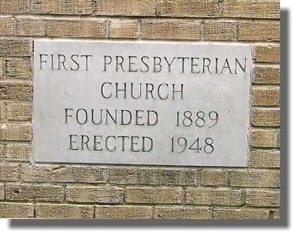
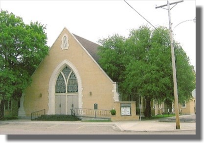
Church Bell, First, Canadian
Marker Location: Purcell & 6th Street, Canadian at Presbyterian
Church
Year Marker Erected: 1967
Marker Text: Bought in 1890 and placed in old Presbyterian Church,
used by several faiths. Was first church bell in Canadian, Hemphill
County. Congregation held suppers and other projects to repay bank
loan on bell. Later bell was moved to
new Presbyterian Church and still is used today. (1967)
First Baptist Church of Canadian, Canadian
Marker Location: Main & 7th Street, Canadian
Year Marker Erected: 1995
Marker Text: This church was organized by seven women in 1894 with
the help of the Rev. Hatcher, a Baptist minister from Amarillo.
Shortly thereafter, about 32 people, converted at a local revival
held by the Rev. Abe Mulkey, joined the new congregation. Early
services and Sunday School classes were held at several area
locations until 1911 when a brick sanctuary was completed. The
congregation erected a fellowship hall and education building in
1954 and a new sanctuary in 1960. The church has grown with the
community and continues to support various outreach and missionary
projects. Sesquicentennial of Texas Statehood 1845-1995.
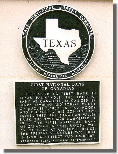
First National Bank of Canadian, Canadian
Marker Location: 2000 Main Street, Canadian
Year Marker Erected: 1970
Marker Text: Successor to first bank in Texas Panhandle: the
Traders' Bank at Canadian, organized by Henry Hamburg and Robert
Moody on August 1, 1887. In 1892 Moody and D. J. Young, his
son-in-law, established the Canadian Valley Bank. The two men
converted it into the First National Bank of Canadian in 1903. Moody
was an official at all three banks. The present structure was built
in 1920. Architect was J. C. Berry. Recorded Texas Historic
Landmark, 1970.
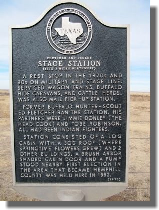
Fletcher & Donley Stage Station, Canadian
Marker Location: Site 3 miles northwest
Year Marker Erected: 1970
Marker Text: A rest stop in the 1870s and '80s on military and stage
line. Serviced wagon trains, buffalo hide caravans, and cattle
herds. Was also mail pick-up station. Former buffalo hunter-scout,
Ed Fletcher ran the station. His partners were Jimmie Donley (the
head cook) and Tobe Robinson. All had been Indian fighters. Station
consisted of a log cabin with a sod roof (where springtime
flowers grew) and (2) other buildings. A brush arbor shaded cabin
door and a pump stood nearby. First election in the area that became
Hemphill County was held here in 1882. (1970)
Hemphill County, Canadian
Marker Location: from Canadian, travel on US 60, north about 1 mile,
marker located at roadside park
Year Marker Erected: 1936
Marker Text: Formed form Young and Bexar territories. Created,
August 21, 1876. Organized, July 5, 1886. Named in honor of John
Hemphill, 1809-1862. First Chief Justice of the Supreme Court of the
State of Texas. Adjutant General of the Somervell Expedition. Member
of the first State Constitutional Convention. Member of the United
States Congress. Canadian, the county seat. (1936)
Hemphill County Courthouse, Canadian
Service Dates: 1909-present
Substantial Modifications: Renovated in 1964: metal windows, metal
door entry. Elevator installed and jail added in 1982
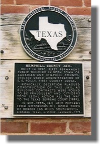
Hemphill County Jail, Canadian
Marker Location: Courthouse Square, Main & 5th Street, Canadian
Year Marker Erected: 1970
Marker Text: Built in 1890, first permanent public building in both
town of Canadian and Hemphill County. Erected under administration
of E. E. Polly, first county judge. Ironically, deception plagued
construction of this jail, as building contracts were found to be
fraudulent and citizens took legal action all the way to the Texas
Supreme Court (1889). In mid-1920s, jail held outlaws from notorious
oil boom town of Borger (65 miles southwest). Recorded Texas
Historic Landmark, 1970.
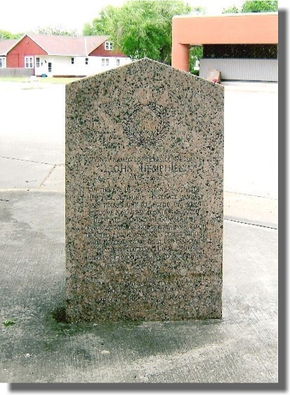
Hemphill, John, Canadian
Marker Location: at Courthouse, Main & 5th Street, Canadian
Year Marker Erected: 1963
Marker Text: (1803 - 1862) Star and Wreath On the eve of secession
U.S. Senator Hemphill set forth to Senate January 1861 Texas right
to secede and again became a sovereign nation. Elected delegate
provisional Confederate
Congress at Montgomery, Alabama which drafted the new nation's
constitution, mobilized manpower, set up financial structure,
elected political leaders. Died in Richmond, Virginia, Confederate
capital. A memorial to Texans who served the Confederacy erected by
the State of Texas 1963.
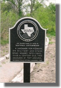
Historic Cottonwood,
133 Yards East to Site of, Canadian
Marker Location: from Canadian, drive north on U.S. 60, turn right
onto FM 2266, about 12 miles to Lake Marvin, turn left at fork at
Lake Marvin entrance, at .7 mile turn to right down dirt road,
continue .3 mile to marker site
Year Marker Erected: 1969
Marker Text: A landmark for pioneers on military and stage road
nearby, 1870-1890. Over a century old, tree measures 21 feet around.
Recorded Texas Historical Landmark, 1969.
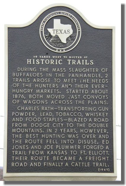
Historic Trails, Canadian
Marker Location: from Canadian, drive about 6.5 miles south on US
60/83, marker is on west side of divided highway
Year Marker Erected: 1969
Marker Text: During the mass slaughter of buffaloes in the
Panhandle, two trails arose to meet the needs of the hunters and
their ever-hungry markets. Started about 1876, both moved vast
convoys of wagons across the plains. Charles Rath-- transporting gun
powder, lead, tobacco, whiskey, and food staples-- blazed a road
from Dodge City to the Double Mountains. In two years, however, the
best hunting was over and the route fell into disuse. Ed Jones and
Joe Plummer forged a trail from Kansas to Fort Elliott. Their route
became a freight road and finally a cattle road.
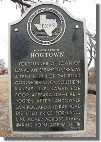
Hogtown, Former Site of
Marker Location: Not located.
Year Marker Erected: 1969
Marker Text: Forerunner of town of Canadian. Sprang up, 1886, as a
tent city for railroad gang working on Southern Kansas line. Named
for poor appearance-- like a hogpen. After landowner Sam Polland and
railroad disputed price for land, line moved across river, taking
populace with it. (1969)
Howe, Gene, Wildlife Management Area, Canadian
Year Marker Erected: 1963
Marker Text: The Gene Howe Wildlife Management Area contains
approximately 6,000 acres of upland sandhills, pastures, natural
meadows and woodlands fronting the north bank of the Canadian River.
Named for Eugene A. Howe, Amarillo newspaper publisher, dedicated
conservationist and member of the Texas Game and Fish Commission for
more than 19 years, the area was acquired by the State in 1951. The
objectives to develop, through research and demonstration, better
methods of game management which can be applied to major vegetative
types found in the High Plains and Panhandle regions of Texas. Chief
projects on the area involve the white-tailed deer, wild turkey,
bobwhite quail and migratory waterfowl. Lesser prairie chickens and
ring-necked pheasants may be found throughout the year and winter
brings a wide variety of visiting shorebirds. To improve wildlife
habitat and increase the yield of natural foods for wildlife, dikes
have been constructed to create marshes which are planted with
waterfowl food plants; brush clearing have been made in the
cottonwood thickets and bottomlands to provide suitable feeding
areas and game openings; small grain is sowed for winter feeding of
deer and turkey. Scientific information acquired through work done
on this Federal-State cooperative project is available to
surrounding landowners and others who are interested. Game surpluses
produced on the area are harvested periodically by hunters under a
controlled public hunt program. (1963)
Isaacs, Mary B., Canadian
Marker Location: located at Canadian Middle School, intersection of
Bungalow & 6th Street, Canadian
Year Marker Erected: 1967
Marker Text: Born in Massachusetts. Came to Texas, 1888, as Hemphill
County's first public school teacher. Often saw Indians darken the
schoolroom windows trying to watch her classes recite Married Will
C. Isaacs in
1892. Founder and guiding spirit of The Canadian Women's Christian
Temperance Union, an organization she served for 44 years. Under her
leadership, W. C. T. U. building doubled as community center and now
houses the city library. Achievements of this pioneer teacher and
civic leader were commemorated in naming of the Mary B. Isaacs
Elementary School. (1967)
Jones Mansion, Canadian
Marker Location: 6th & Main Streets, Canadian
Year Marker Erected: 1983
Marker Text: Prominent area rancher Thomas Stanley Jones, a native
of Wales, had this home built in 1910 for his wife, Rosalie
(Whaley), and their children. Designed by Amarillo architect E.
Wellington, it was the first brick residence constructed in
Canadian. Reflecting its builder's prominence in the town, the
classical revival mansion features monumental Ionic columns, red
brick corner quoins, and renaissance detailing. Recorded Texas
Landmark Landmark, 1983.
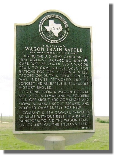
Lyman's Wagon Train Battle, Site of, Canadian
Marker Location: from Canadian, travel south on US 60/83
approximately 7 miles, turn east on SH 33 and go about 10 miles -
marker is on south side of road
Year Marker Erected: 1967
Marker Text: During the U.S. Army campaigns in 1874 against
marauding Indians, Captain Wyllys Lyman led a wagon train to Camp
Supply, Oklahoma, for rations for General Nelson A. Miles' troops on
duty in Texas. On the way, Indians attacked, and the longest Indian
battle in Panhandle history ensued. Fighting from a wagon corral
September 9 to 14, Lyman and 95 soldiers held off about 400 Comanche
and Kiowa Indians. A scout escaped and reached Camp Supply for help.
Company K, 6th Cavalry, traveled 80 miles without rest in a raging
rainstorm to aid the wagon train. On its arrival, the Indians fled.
(1967)
Marcy Trail, Route of, Canadian
Marker Location: from Canadian, drive on US 60, south about 8 miles,
marker is on west side of the highway
Year Marker Erected: 1969
Marker Text: This overland route, blazed in 1849 by energetic and
efficient Army Captain R. B. Marcy, was best known as part of the
California Gold Trail. Starting in Oklahoma, Marcy led an expedition
across the Texas Panhandle and back through central West Texas. Both
of the wagon roads he laid out served the emigrant traffic. In 1853,
this section was planned as part of the route for the first
transcontinental railroad in America, but the Civil War shifted
sentiment to northern routes. Its importance declined after the
railroad came through this county, 1887. (1969)
McGee, Tom T., Canadian
Marker Location: Canadian Cemetery, located in the east section
-Canadian
Year Marker Erected: 1967
Marker Text: (Sept. 13, 1849 - Nov. 24, 1894) Came to Canadian about
1884. Was foreman on Po Ranch prior to election as first sheriff of
Hemphill County, 1887 - year city of Canadian was founded. Nov. 23,
1894, in gun fight with (6) men attacking large shipment of money at
Wells, Fargo & Company, he was mortally wounded, and he died the
next day. His widow went to England as a volunteer civilian worker
in World War I; died there. Ashes were returned here for burial.
Recorded, 1967
Miles Expedition, General Nelson Miles' Headquarters Dugout,
Canadian
Marker Location: US 83, just north of Washita River
Year Marker Erected: 1967
Marker Text: Indian raids brought Miles' men to Texas from North in
1874 as part of U.S. Army pincer's tactic operating from a dugout
post. The 12 Infantry and cavalry units had supply camps on the
Canadian, Red and Washita rivers. On November 8, 1874, Miles' troops
recovered three captive German sisters; fought 8 Indian battles
during winter. At this post General Miles nominated for Medal of
Honor several of his men -- among them renowned Panhandle settler,
Billy Dixon. In 1875, Fort Elliott was opened at Old Mobeetie to
continue frontier
protection. (1967)
Military Road, Old, Canadian
Marker Location: from Canadian, drive US 60, north about 3 miles,
turn east on FM 2266, marker is located about 12 miles east at
entrance to Black Kettle National Grassland Campground
Year Marker Erected: 1969
Marker Text: (1874 - 1890) One of earliest known Texas Panhandle
trails. Flint-pierced mastodon bones show prehistoric men trailed
this valley before Indians were here. In 1875, U.S. Army came this
way to Fort Elliott, at Mobeetie (30 miles, southwest). Mail routes
and stagecoaches used this trail, 1878-1890. (1969)
Moody Hotel, Canadian
Marker Location: insection of Main & 2nd Streets -Canadian
Year Marker Erected: 1970
Marker Text: In 1910 Canadian was a thriving railroad and marketing
center with a Baptist Academy. English-born Robert Moody
(1838-1915), a rancher, banker and trustee of the academy, decided
to build a hotel that would reflect the town's prosperity. On the
site of the former McIntosh Hotel, he began construction of this
brick veneered building. The 3-story facility opened in late 1910
with 40 guest rooms and a beautiful oak stairway. The Moody Hotel
became a local landmark and a popular stop for visitors until
changing travel customs caused it to close. (1978)
A rest stop in the 1870s and 80s
Marker Location: Located 21 & 8/10 mile SE of Canadian on US
277.
Year Marker Erected: 1970
Marker Text: A rest stop in the 1870s and 80s on military and stage
line. Serviced wagon trains, buffalo hide caravans, and cattle
herds. Was also mail pick-up station. Former buffalo hunter-scout Ed
Fletcher ran the station. His partners were Jimmie Donley (the head
cook) and Tobe Robinson. All had been Indian fighters. Station
consisted of a log cabin with a sod roof (where springtime flowers
grew) and 2 other buildings. A brush arbor shaded cabin door and a
pump stood nearby. First election in the
area that became Hemphill County was held here in 1882.
River Valley Pioneer Museum, Canadian
Mailing Address: P O Box 1201
City: Canadian
Zip code: 79014
Street Address: 118 N 2nd
Area Code: 806
Phone: 323-6548
Email Address: rvmuseum@arn.net
Types of Exhibits/Collections: Art, Natural History, Archeology,
Photos, Historical, Local/Pioneer History
Educational Programs: Guided Tours, Self-guided tours, Traveling
Trunks, Hands-on Activities for Children, Demonstrations,
Intrepretive Drama, School/Museum Cooperative Curriculum, Special
Programs/Accomodations for Disabled Visitors
Springer's Road Ranch, Site of Old, Canadian
Year Marker Erected: 1967
Marker Text: First post office in Hemphill County. Unique for tunnel
from dugout home-store to corral. On 1870's trail from Fort Elliott
(35 miles, southwest) to Fort Supply, Indian Territory, to Fort
Dodge, Kansas. Established by A. G. Springer; besides running 300
head of cattle, Springer's was a stagecoach stand, tavern; store
(mainly for teamster, hunters) had liquor, canned goods, hunting
equipment. Poker-expert Springer was frequent host to soldiers
seeking entertainment in tavern. In 1877, he and Tom Ledbetter, his
partner, were killed in gun battle with angered soldiers and were
buried at the ranch. (1967)
W. C. T. U. Building, Canadian
Marker Location: 500 Main Street, Canadian
Year Marker Erected: 1965
Marker Text: Only structure in the nation built, owned and still
operated by a local chapter of Women's Christian Temperance Union.
Built 1911, with financing and upkeep from annual bazaars held since
1906. Also, used by public library and civic groups. Determined to
abolish liquor by local option election, the chapter organized in
1902. Won first election a year later. Meetings have been held every
Wednesday since founding. Recorded Texas Historic Landmark, 1965
Wood, Sam,
Cabin, Canyon
Marker Location: located at Panhandle-Plains Museum, in Canyon,
Randall County
Year Marker Erected: 1966
Marker Text: Sam Wood cabin built in 1887 at Hog Town (now a ghost
town). Wood, an Indian Scout, Union veteran of Civil War, buffalo
hunter, was father of bride in first marriage recorded in the
Panhandle, at Fort Elliott in 1877. Cabin housed (6) families during
an Indian scare, in 1954 it was moved, restored. Recorded Texas
Historic Landmark, 1966.
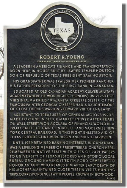
Young, Robert R., Canadian
Marker Location: from Canadian, drive on US 60 about 1 mile north,
marker is in roadside park
Year Marker Erected: 1967
Marker Text: (February 14, 1897 - January 25, 1958) A leader in
America's finance and transportation. Born here, in house built by
lawyer Temple Houston, son of Republic of Texas President Sam
Houston. His grandfather was traildriver, pioneer rancher; his
father, president of the first bank in Canadian. Educated at Old
Canadian Academy, Culver Military Academy (where he won highest
honors), University of Virginia. Married, 1916, Anita O'Keeffe,
sister of the famous painter Georgia O'Keeffe. Had a daughter. One
of close friends was King Edward VIII of England. Assistant to
treasurer of General Motors, 1920s. Made fortune in stock market in
1929. After years on Wall Street, won acclaim of financial world in
a proxy battle to gain control of and modernize New York Central
Railroad. In this fight, enlisted aid of Texas friends Clint
Murchison and Sid Richardson. Until 1939, retained banking interests
in Canadian. Was a lifelong member of Presbyterian church here.
Remembered native state with gifts of rare papers to University of
Texas. Restored an historic local burial ground, naming it "Edith
Ford Cemetery," to honor an aunt who reared him after early death of
his mother. Maintained close ties (in visits, hunting trips,
correspondence) with people known in boyhood. (1967)
Texas Historical Commission
http://www.thc.state.tx.us/hemphill.html
Texas Historic Sites Atlas - Search Frames Page
http://atlas.thc.state.tx.us/Atlas/atlas_search_frame.html