


Coppell, Texas
USGenWeb >> TXGenWeb >> Dallas County >> Towns & Communities >> Coppell, Texas
 |
|
| Latitude |
32°58′2″N 32.967341 |
| Longitude |
96°59′12″W -96.986564 |
| Elevation feet/meters |
518/158 |
| Zip Code | 75019, 75099 |
| Founded | |
| GNIS FID | 1373209 |
| TXGenWeb Site | |
| Cemeteries | |
| Library | |
| Local Genealogy Society | |
| Wikipedia | |
| ci.coppell.tx.us | |
The Coppell (/kəˈpɛl/ kə-PEL) area was settled by German and French immigrants in the 1840s. Members of the Peters Colony also settled here in the 1840s. Originally named Gibbs Station, after Barnett Gibbs (one of Texas's first lieutenant governors), the town was renamed in 1892 for George Coppell, a wealthy English financier who came to the United States in the 1880s and was reportedly heavily involved with the final construction of the local railroad line. Popular belief is that he was an engineer, but there is little or no evidence to support that claim.
|
||||||||||||||||||||||||
In 1955, the community was incorporated through a ballot measure that passed by a vote of 41 to 1. Spurred by the opening of Dallas/Fort Worth International Airport in 1974, the city was radically transformed from a tiny farming village to a large, upper-middle class suburban community in the 1980s and 1990s. By 2000, almost all of the residentially zoned land in the city was developed, and the population grew to over 35,000. In addition to suburban homes, the city has a growing commercial base of warehouses and transportation centers on the south and west sides of the city, closest in proximity to the airport.
Matthew Hayes Nall
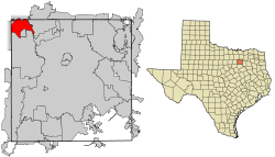
Coppell is on Interstate Highway 635, U.S. Highway 121, Interstate Highway 35, the Elm Fork of the Trinity River, and the St. Louis Southwestern Railway, seven miles from Farmers Branch in the extreme northwest corner of Dallas County. The community is bordered by Irving, Grapevine, and Carrollton and is northeast of Dallas-Fort Worth International Airport. Grapevine Creek, Denton Creek, and Cottonwood Branch flow through the city. The area was on the original land grant of J. A. Simmonds. President Sam Houston and Republic of Texas troops camped on Grapevine Creek during negotiations with area Indian tribes in an effort to enlist their aid in defending the republic against attacks by Mexican troops in 1843.
The site was first settled in the mid-1800s by James Parish, from Goliad. In 1887 the community secured a post office. It was originally named Gibbs Station, after Texas lieutenant governor Barnett Gibbs, a large landowner in the area. In 1888 construction of the St. Louis, Arkansas and Texas Railway through the town was completed. In 1892 the post office was renamed Coppell, in honor of a railroad employee and pioneer settler of the region, George A. Coppell. In 1914 the settlement had two churches, two general stores, two blacksmiths, a bank, a hardware store, telephone service, a population of 450, and dealers in poultry, livestock, and lumber. However, by 1926 the population had decreased to 200, where it remained for three decades.
BIBLIOGRAPHY: Dallas Guide and History (Washington: WPA Writers' Program, 1940). Dallas Times Herald, March 12, 1984.
Handbook of Texas Online, Matthew Hayes Nall, "COPPELL, TX"
..... Read More TSHA .....