


Grand Prairie, Texas
USGenWeb >> TXGenWeb >> Dallas County >> Towns & Communities >> Grand Prairie, Texas
 |
|
| Latitude | 32° 42' 55" N 32.715278 |
| Longitude | 97° 1' 1" W -97.016944 |
| Elevation feet/meters |
515/157 |
| Zip Code | 75050-75054 |
| Founded | |
| GNIS FID | 1336802 |
| TXGenWeb Site | |
| Cemeteries | |
| Library | |
| Local Genealogy Society | |
| Wikipedia | |
| gptx.org | |
|
|||||||||||||||||||||||||||||||||||||||
.... Read More Wikipedia ....
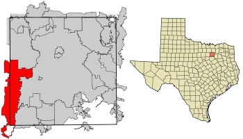
Grand Prairie is on U.S. highways 80 and 303, Interstate highways 20 and 30, and Farm Road 1382, thirteen miles west of downtown Dallas in western Dallas and eastern Tarrant counties. The townsite comprises seventy-three square miles enclosed by Dallas, Arlington, Irving, and Cedar Hill. Mountain Creek Lake is on the east, a portion of Joe Pool Lake is in southern Grand Prairie, and Kirby, Cottonwood, and Fish creeks flow through the community. Settlers arrived in the area before the Civil War and built several stores, including the M. M. Miller store and the Phillip Goetsell store. The community was not organized, however, until 1863 when A. M. Dechman's wagon broke down on his trip from Jacksonville, Texas, to Fort Belknap with supplies for the army commissary. He traded his broken wagon, ox team, and $200 of Confederate money for a 239-acre tract that had originally been granted on May 1, 1850, to William and Walter Caruth.
The community became officially known as Dechman or Deckman when it received a post office in 1874. W. M. Haskett was the first postmaster, and the post office was on land donated by Dechman. By that time a daily stage ran through Deckman on its way from Dallas to Fort Worth, and in 1875 a stage was robbed right outside the community. Early churches in the area included the West Fork United Presbyterian Church, built in 1870 and located in Tarrant County in a community then known as Watson, and the Valley Church on the Dallas County side with a log building that served as both a nondenominational church and a school.
.... Read More TSHA ....