Sand Branch, Texas
USGenWeb >> TXGenWeb >> Dallas County >> Towns & Communities >> Sand Branch, Texas
 |
|
| Latitude | 32° 38' 6" N 32.635 |
| Longitude | 96° 37' 11"W -96.619722 |
| Elevation feet/meters |
Unknown |
| Zip Code | |
| Founded | |
| GNIS FID | 2033814 |
| TXGenWeb Site | |
| Cemeteries | |
| Library | |
| Local Genealogy Society | |
| Wikipedia | |
| The present day saga on one Texas non-border colonia | |
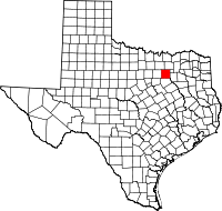
Sand Branch (sometimes spelled Sandbranch) is an unincorporated community in Dallas County.
Sand Branch is located approximately two miles south of U.S. Highway 175 and 14 miles southeast of Downtown Dallas on Belt Line Road in southeastern Dallas County. It is situated between the Trinity River and Hickory Creek, southwest of Seagoville. Sand Branch is the only unincorporated settlement left in Dallas County, as the vast majority of the county lies within incorporated cities.
The Sand Branch Community has long been considered one of the poorest areas in Dallas County. The area's living conditions and lack of basic services have led some to label the largely lower-income, predominately African American community a "non-border colonia" because of its similarities to those settlements situated along the southwestern United States border with Mexico. One of the challenges of the community is that residents must transport water to use it: despite existing next to a Wastewater Treatment facility, no water infrastructure exists in Sand Branch (due to its unincorporated status), and the wells are non-potable due to decades of contamination.
Laurie E. Jasinski
Sand Branch is a small community located about fourteen miles southeast of downtown Dallas in southeastern Dallas County. The town, situated between the Trinity River and Hickory Creek, was possibly named for the area geography. Sand Branch existed by the latter decades of the twentieth century. In 2000 the population was 400.
Handbook of Texas Online, Laurie E. Jasinski, "SAND BRANCH, TX"


