| CEMETERY
NAME |
COORDINATES |
INFO
&
LOCATIONS
|
| Abney-Rudd Cemetery |
|
Abandoned. There is no cemetery by this name at
present. Some of the Abney family previously buried in an old cemetery
near the Ark-La Plant at Waskom were moved in later years to Colonial
Gardens. Some of the Rudd family were moved in later years to Restland
in Waskom. |
| Adam |
|
African-American
- From Marshall, take Hwy 59 north to Hwy 1793. Turn right onto 1793
(Fern Lake Road), and the cemetery is on the south side of the road, about
1/2 mile west of Collier's Chapel. |
| Algoma Cemetery |
[323245n, 0942031w] |
Partial
- In Marshall, this cemetery is located on the north side of East Houston
Street, in the 2400 block, south of Hwy 80 and east of Hwy 59. Founded
about 1924. |
| Anderson Family Cemetery (AKA Edgemont or Hall's Hill) |
|
See
Hall's Hill |
| Andrews Cemetery |
|
Located
3.0 miles south of Karnack; This cemetery is located on Hwy 43 between
Karnack and Marshall. From Marshall on Hwy 59, go North on Hwy 43 to Karnack.
The sign will also say to Caddo Lake. Go about 11 miles from the Marshall
city limits and the Andrews Cemetery will be on your left.
|
| Annie-Haggerty |
|
African-American |
| Antioch Cemetery |
[323617n, 0940804w ] |
African-American
- Take I-20 east to exit 628. Go north on FM 134. The cemetery is just east
of the junction of FM 134 and FM 1999, on the north side of the road, before
the village of Leigh. |
| Athens Cemetery |
|
African-American
- At the end of County Road 3711 (Joe Walker Road). |
| Batts Cemetery |
|
African-American
- Off Fern Lake Road, 1793. Go past the Pope City road (CR 2012), turn
right to Friendship Church on Owens Corner road (CR 2107), to the Batts
Cemetery. |
| Bellview |
|
African-American
- Located west of Waskom. 1/2 mile north of Hwy 80 on CR 2729 (Bellview
Road). |
| Bethesda |
|
See
Woodlawn |
| Blalock-Munden Cemetery |
|
On
private property on Hwy 43, about 1 1/2 mile south of I-20. |
| Blocker Cemetery #1 (AKA Blocker-Ware) |
[322652n, 0941652w] |
(History)
From Rosborough Springs, take FM 2625 east approximately 3.75 miles. Cross
Blocker Road and the cemetery is about another .3 miles, on the south side of
FM 2625. |
| Blocker Cemetery (#2) (AKA Levin-Perry or Old Blocker) |
[323734n, 0940702w] |
Abandoned. On private property. Take I-20 east
to exit 628. Go north on FM 134. From the junction of FM 1999 and FM 134,
continue east on FM 1999 to FM 9. Go north on FM 9 approximately 1.3 miles.
Turn west on the last road before the railroad tracks and go to the end of
the road. |
| Blocker-Levin-Perry Cemetery |
|
See
Blocker #2 |
| Blocker-Ware Cemetery |
|
See
Blocker #1 |
| Bluff Springs Cemetery
(AKA Simmons) |
|
In
the Harleton area, in Simmons Community, near Ashland. On CR 4508
(Simmons Cemetery road). This cemetery is located off a blacktop road to
Simmons Church. |
| Boisseau Cemetery |
|
|
| Border Cemetery |
|
See
Old Border |
| Bray Family Cemetery |
|
Abandoned,
on private property in the south Hallsville area. |
| Briggs Cemetery |
|
PRIVATE
PROPERTY - This cemetery is located on private land south east of Woodlawn,
near CR 2109 (Buckhorn road). There are approximately 10-12 graves located
here, but only one is marked, that of John Wesley Briggs, b. 1841 TN, d.
1-13-1911, Karnack, Harrison Co. TX. The other graves are reported to
be slave graves. |
| Britt Cemetery |
|
Abandoned. On private property near Leigh, off FM
134. There are 4 marked graves. |
| Bucksville Cemetery |
|
African-American
- Take Hwy 80 East from Hallsville. Go to Firetower Road and turn left. Go
about 5 miles to CR 3806, Bucksville Road, and turn left. The cemetery is at
the end of the road on the left. |
| Bullard Cemetery |
|
See
Old Bullard |
| Canaan Cemetery |
|
African-American
- From Marshall, take I-20 west to Hwy 43. Go south on Hwy 43 to CR
3008 (Canaan Church Rd). The cemetery is behind the church. |
| Cain Cemetery |
|
From
Longview, take Hwy. 80 East and go 4.4 miles past the Harrison Co. marker.
Turn right on Lancing Switch Road and go 0.2 miles. Turn right on Cain
Cemetery Rd. The cemetery will be straight ahead on your left. |
| Calvary Cemetery |
[323019n, 0941903w] |
Now
a part of Colonial Gardens Cemetery - On Hwy 31 between Marshall &
I-20. Sullivan Funeral Home has the records. |
| Carter Cemetery |
|
African-American
- Located on the south side of CR 2200 (Marshall-Leigh road). Carter
Cemetery is behind the Minneweather Cemetery. |
| Cartersville Cemetery |
|
Located
on FM 449. From Hallsville, take FM 450 north to FM 449. Go west
on 449. Sign is hard to see so watch closely. |
| Catholic Cemetery |
|
See
Saint Joseph's Cemetery |
| Cave Springs Cemetery |
|
From
Marshall, go south on Hwy 43 to the intersection of Hwy 43 & CR 2625
(Rosborough Springs Rd). The cemetery is on the right (west) side of the
highway, 4.4 miles south of I-20, just north of the Sabine River. |
| Center Cemetery |
[323946n, 0943423w] |
From
Harleton, TX, go south on FM 450 approximately 1 mile from where you leave
Hwy 154. The cemetery is on east side of road, just north of the junction of
FM 450 and FM 2208. |
| Center Hill Cemetery |
|
See
Sunny Hill |
| Champion Cemetery |
|
From
Marshall, travel south on Hwy 43. At
the Cave Springs Church turn right. One half mile from the church you cross a
creek and turn left. Follow this road 2.6 miles. At this point there are 4
mail boxes on the right side of the road and a drive that turns to the right.
The cemetery is approximately 1/2 city block on the right side of the drive.
It is about 200 yards from the drive. This was the old Champion home place. |
| Choate Cemetery |
|
On
private property off of Haynes road. |
| Clark Cemetery |
|
- |
| Cock Cemetery |
|
Abandoned
-This cemetery no longer exists, with no records found. Reported to be
on the Shady Grove 4H demonstration plot near Woodleyville, about 200 yards
off the road on a little flat hill. |
| Cole Cemetery |
|
Abandoned. African-American & White - On private
property. On CR 3705 (Walker's Mill Road) behind the first house on the
left. In two sections, the lower one was used for African-American
burials. |
| Colonial Gardens |
|
Located
in Marshall on Hwy. 31, between I-20 and Marshall. Records are
available at Sullivan Funeral Home. |
| Concord Cemetery |
[323055n, 0940642w ] |
On
private property. From I-20, exit 628, take Hwy 80 east approximately
.2 miles, then go north on FM 134 through Jonesville. FM 134 makes a hard
right turn in Jonesville. Continue on FM 134 approximately 1.4 miles, then
turn east on Concord Road. Cemetery is on the south side of the road,
approximately .4 miles from FM 134. |
| Cornerstone Church Cemetery |
|
Located
In Harleton. |
| County Farm Cemetery |
|
Indigent
burials in the early 1900's |
| County Line Baptist Cemetery |
[32 45.47'N, 094
41.87'W] |
From
Harleton take FM 450 northwest toward Ore City for about 7 miles. When it
intersects with FM 726, turn left. The cemetery and church are approximately
2 miles on the north side of the road. (County Line Baptist Cemetery
booklet scans) |
| Cox's Hill Cemetery |
|
See
Grimes Cemetery |
| Crain Cemetery |
|
On
private property in the south Hallsville area. |
| Craver Cemetery |
|
Located
off Driskel Bridge road about 11 miles northwest of Marshall. |
| Crockett Cemetery |
|
African-American
- Located about 2 miles north of Harleton on FM 1968, then on CR 4735
(Crockett Cemetery Road). The road dead ends at the cemetery. |
| Crossroads Cemetery |
|
From
Marshall, go south on Hwy 31 for 4.6 miles and the cemetery is on the left
hand side of the road, beside the Crossroads Methodist Church. |
| Darco Cemetery |
|
- |
| Davidson Chapel Cemetery |
|
Private
Cemetery In the Harleton area where Federal Judge T Whitfield Davidson is
buried. |
| Davis Cemetery |
[323627n, 0940726w] |
African-American
- Take I-20 east to exit 628. Go north on FM 134. From the junction of FM 134
and FM 1999, take FM 1999 east approximately .6 mile. Turn north on an
unnamed road. Go approximately .1 mile; take the first right and go to the
end of the road. |
| Davis Cemetery (#2) (AKA
Old Davis) |
[323731n, 0944033w] |
On
private property. From Longview, take Hwy 259 north. About 6.3 miles
north of Longview Hospital, turn east on FM 449 about 4.5 miles, crossing
back into Harrison Co. Turn north on FM 2879 and go approximately 1.4 miles.
Bear left at a fork and go another .4 miles. The cemetery is on the west side
of the road, between the road and a creek, near the Cypress River bridge, on
a hill. |
| Dean Cemetery |
[323624n, 0940328w ] |
Private
cemetery. Take I-20 east to exit 628. Go north on FM 134. From the
junction of FM 134 and FM 1999, take FM 1999 east approximately 4.5 miles.
Take the last road on the left before the power lines and follow it about .3
miles. The cemetery is on the south side of the road, just before the power
lines. |
| Dixon Memorial Garden |
|
Hallsville |
| Dollahite Cemetery (AKA as Forrest-Rogers-Dollahite) |
[322628n, 0943528w] |
From
I-20, exit 604, take FM 450 south for approximately 1.7 miles until it
intersects FM 968. Turn west on FM 968 and go about .9 miles. Turn south onto
Quail Lane. In just under .4 miles, the cemetery will be on the east side of
the road. |
| Driskell Cemetery |
|
African-American
- Located on FM 1793, 1/4 mile west of Colliers Chapel on the west (left)
side of the road. You will see a steel gate to the cemetery. |
| Eagle Creek Cemetery |
[324040n, 0943715w] |
Located
west of Harleton, Texas on Hwy 154 W.(Approximately 15 miles west of
Marshall) |
| Ebenezer Cemetery |
|
African-American
- West of Marshall on Hwy 154 at the Ebenezer Church. |
| Eddington Cemetery |
|
No
markers remaining. Off Hwy 31 going to Elysian Fields, next to Acie
Johnson's house. |
| Edgemont Cemetery (AKA Anderson Family or Hall's Hill) |
|
See
Hall's Hill |
| Elizabeth Cemetery |
|
African-American
- From the corner of FM 1999 and FM 9, go north on Hwy 9, 3.0 miles. The
Cemetery is on your right; the church is across the street on your left. |
| Elysian Fields Cemetery
(New Town) |
|
East
of Elysian Fields on FM 451. |
| Elysian Fields Cemetery
(Old Town) (AKA Boisseau) |
|
Abandoned. Private Property - 2 miles east of New Town
Elysian Fields Cemetery on FM 451, near the Elysian Fields Baptist
Church. |
| Fairview Cemetery (AKA Hope Chapel) |
[323051n, 0942214w] |
Go
south on US-59 to E. Carolanne. Go west approximately 1 mile to Lynoak
Street. Go south one block and the cemetery is on the west side of the road. |
| First Community |
|
African-American
- Harleton |
| Fisher Cemetery |
|
- |
| Forest Hills Cemetery |
[No coordinates
available] |
Located
approximately 20 miles west of Marshall, Texas off Hwy 449 on FM 2879 at
the Forest Hills Baptist Church. |
| Friendship #1 |
|
Abandoned. Near the Noonday Community on private
property. |
| Friendship #2 (AKA
Gill) |
|
See
Gill |
| Ft Crawford Cemetery |
|
Abandoned. Hallsville area on private property. |
| Gainsville Cemetery (AKA
Hunter) |
[323712n, 0941906w] |
From
Marshall, go north on Hwy 59 approximately 1.1 miles from where Hwy 59
crosses Loop 390. Turn right onto FM 1793 (Fern Lake Road). Follow this
approximately 2.6 miles, through the village of Gainsville. The cemetery is
on the east side of the road, approximately .2 miles before Suburban Acres
Road. |
| Gibson Cemetery |
|
- |
| Gill Cemetery (AKA Friendship #2) |
|
On
FM 1186. Take Hwy 59 south from Marshall. Turn left on FM 1186
and the cemetery is adjacent to Friendship Baptist Church |
| Golden Rule Cemetery |
|
On
CR 3322 at the end of Timberlake Road. |
| Granberry Cemetery |
|
Private
Property - On CR 111, south of I-20. |
| Granbury Cemetery |
[322836n, 0941252w] |
From
I-20, exit 624, take FM 2199 south approximately 1.75 miles. Turn east on
Newton Road and go about 1.5 miles to a three way intersection. Turn north on
Kelley Lane and go about .5 miles. The cemetery is on the east side of the
road. |
| Grange Hall Cemetery |
|
From
Marshall, travel south on Hwy 43.
Located In the Grange Hall Community just north of I-20 on Hwy 43, on
the west side of the road. |
| Greater Rock Springs Cemetery |
|
African-American
- From Marshall, take I-20 west to Hwy 43. Go south on Hwy 43.
Pass FM 2625, then go left down a private road. See the Greater Rock
Springs Church for entry. |
| Greenwood Cemetery |
[323314n,"0942234w] |
In
Marshall, from Hwy 80, take David Street north four blocks to Herndon Street.
Turn east on Herndon, and the cemetery will be on the north side of the
street. It is near East Texas Baptist University. |
| Grier Cemetery |
|
- |
| Grimes Cemetery (AKA Cox's Hill Cemetery) |
|
On
private property near Woodleyville. Two graves. |
| Grover Cemetery (Both new and old) |
[323117n, 0942638w] |
From
Marshall take Hwy 80 west about 3.5 miles after you cross over the railroad
tracks. Take FM 968 south about .25 miles for the new section and .5 miles
for the older section. The old cemetery is on the east side of 968 and the
new cemetery is on the west side of 968. |
| Gum Springs Cemetery |
|
From
Marshall - Take I-20 west to exit 599, you will exit onto Loop 281. Gum
Springs Rd is the 1st left hand turn almost immediately after exiting, NOT
the frontage road which will return you to I-20. Take Gum Springs Rd for
about 1/2 a mile and cemetery is on the right. Almost in Longview, but
in Harrison County. |
| Haggerty Family Cemetery |
|
Abandoned. On private property near Karnack. |
| Haley Cemetery |
|
African-American
- From Marshall, take Hwy 43 east to CR 2200. Go east on CR 2200
(Marshall-Leigh Road) past James Chapel. The cemetery is in the woods. |
| Hall's Chapel (AKA Ewing Chapel) |
[322554n, 0942232w] |
From
Marshall, take Hwy 59 south. About 4.1 miles after crossing I-20, take FM
2625 west approximately 1.8 miles. Turn north onto FM 3017 (Middle Rosborough
Springs Road). The cemetery is on the east side of the road. |
| Hall's Hill-Edgemont Cemetery |
|
West
of Marshall, FM 3379 on private property. |
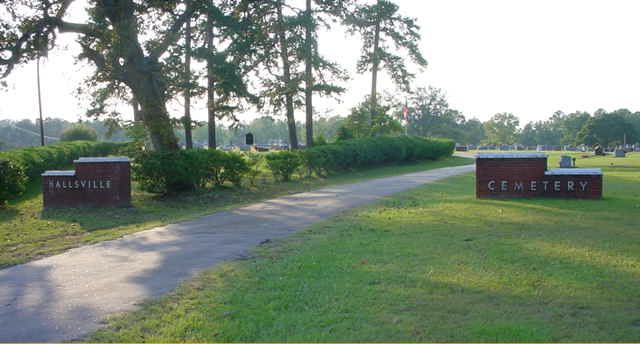
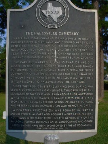
| Hallsville Cemetery |
|
Pic
#1 Pic #2 Traveling east on Hwy. 80 from
Longview, turn right at the second red light in Hallsville onto S. Central
Street. Cross the RR tracks and turn right onto Willow. Go around the curve
and the cemetery will be on the right. |
| Ham Cemetery |
|
On
private property. South of Marshall off Hwy 43, near Grange Hall. |
| Hampton Cemetery |
|
- |
| Harkins Cemetery (AKA
McAlister) |
|
Abandoned. Located on oil road (International Paper
Company land) about 5 miles north of Waskom near TX/LA line. Behind what was
Mr. Barry Rudd's old red barn. |
| Harkrider Cemetery (AKA
Timmons) |
[322136n, 0941318w] |
Abandoned. From I-20, exit 620, take FM 31 south to
Elysian Fields. In Elysian Fields, take West Street west about 2.5 miles,
crossing over into Panola County. West St. runs into CR 312. Take that west
.4 miles to a road heading north, PR 1334. Cross back into Harrison County.
The cemetery will be on the east side of the road, about .6 miles from CR
312. |
| Hayner Cemetery |
|
Located
on the Caddo Lake Wildlife Refuge [formerly-Longhorn Army Ammunition Plant]
Karnack TX. The guards at the gate and the Friends of Caddo Lake
Wildlife Refuge can give instructions and maybe even escort anyone wishing to
visit the sites. |
| Hebrew Cemetery |
|
Jewish
Cemetery - Located in Marshall on Herndon St. |
| Hebron Cemetery |
[323602N, 0943915W] |
Located
on FM 449, at the intersection of FM 2208 & FM 449 between Marshall and
Longview, next to the Hebron Baptist Church. |
| Hendricks Cemetery |
|
See
McKay Cemetery |
| Hickory Grove Cemetery |
|
African-American
- Unmarked. No name on it, no fence, just a few graves beside the road. From
Marshall, follow Hwy 59 to Woodlawn.
Turn left and cross the railroad tracks. Follow this road to Lee Island Road which
intersects from the right. The
cemetery is in a field directly across from the Lee Island Road. |
| Hightower Cemetery (AKA
Hightower-Jernigan) |
|
Located
on private property at intersection of FM 9 & FM 451 near the
Harrison-Panola Co line. |
| Hill Family Cemetery |
|
Abandoned. South of Waskom on CR 1222. |
| Hope Cemetery |
|
In
Karnack close to the intersection of Spur 449 and FM 134. |
| Hope #2 Cemetery |
|
Located
on the Caddo Lake Wildlife Refuge [formerly-Longhorn Army Ammunition Plant]
Karnack TX. The guards at the gate and the Friends of Caddo Lake
Wildlife Refuge can give instructions and maybe even escort anyone wishing to
visit the sites. |
| Hope Chapel Cemetery |
|
See
Fairview |
| Hope Springs Cemetery |
[324133n, 0943020w}] |
From
south east of Harelton, take FM 2208 north east for approximately 2.7 miles.
Turn north on Johnson Road. Follow Johnson Road until it passes under a power
line. At a "Y" junction, follow the left fork towards Hope Springs
Lake. From the "Y" junction, go about .2 miles and cemetery should
be on the left or south-west side of the road. |
| Hudson Cemetery (AKA Saint Paul's Cemetery) |
[323322n, 0941957w] |
African-American
- From Marshall, take Hwy 43 east from Hwy 59 about 1 mile. Turn north (left)
onto Bausley Road. When Bausley Road makes a sharp turn to the east, the
cemetery should be on the east or south side of the road. |
| Hunter Cemetery |
|
See
Gainsville |
| Jernigan |
|
See
Hightower |
| Jewish Cemetery |
|
See
Hebrew Cemetery |
| Johnson Cemetery |
|
On
private property. |
| Keasler Cemetery |
|
Abandoned
on private property. Only 1 known marker. |
| Kimberline Cemetery |
|
Abandoned. Near FM 968 & FM 450. |
| Koon-Dickard Cemetery |
|
- |
| LaGrone's Chapel Cemetery |
|
From
Hallsville, travel north on Hwy 450, turn left at Noonday Road, travel 3.8
miles to the corner of Hwy 2208 and CR 3600 (Noonday Rd) |
| Lary-Waskom |
|
See
Waskom Family |
| Levin Perry Cemetery (AKA
Blocker or Old Blocker) |
|
See
Blocker Cemetery #2 |
| Lewis Cemetery |
[322221n, 0941010w] |
African-American
- From I-20, exit 620, take FM 31 south to Elysian Fields. In Elysian Fields,
take FM 451 east about .8 miles. Turn south on CR 1211 (Lewis Cemetery Road).
Go just over .1 miles. The cemetery will be on east side of the road. |
| Liberty Cemetery |
[324247n, 0943313w |
From
Harleton, take Hwy 154 north east to FM 450. Turn onto FM 450 and in about .2
miles, turn north onto FM 1968. Take this due north for 2.1 miles. Turn east
onto Baker Lane. When Baker makes a "T" junction with Liberty Road
(CR 4713), turn north. Follow Liberty Road for approximately 1 mile. At the
intersection of Liberty Road and the first road on the right past Hickory,
the cemetery is on the south side (right) of Liberty Road. Near the Marion
County line in the Lake Deerwood area. |
| Liberty Cemetery |
|
African-American
- South of Marshall on Hwy 59 at the intersection of CR 1026 (Liberty Cut Off
Road). The cemetery is at the Liberty Church. |
| Lilly Hill Cemetery |
[323347n, 0943928w] |
From
Hallsville, take FM 450 north to Noonday Road West. Go west on Noonday Road
about 3.9 miles to the junction with Old Jefferson Road (FM 2208). Turn south
west onto Old Jefferson Road and go about .5 miles. Cemetery is to the south
east from the road. |
| Long Ridge Cemetery |
[322753n, 0941043w] |
African-American
- From I-20, take the exit for Web Rogers Road south [between exits 624 and
628. Take Web Rogers Road south about 1.6 miles and turn east onto Ira
Williams Road. about .8 - .9 miles and the cemetery will be on south side
(right) of the road. |
| Love Cemetery |
|
- |
| Macedonia Cemetery (AKA
Old Macedonia) |
[323645n, 0942337w] |
African-American
- From Loop 390 north west of Marshall, take FM 1997 north about 3 miles.
Turn west onto CR 4103 (Macedonia Road). Go between .1 and .2 miles and the
cemetery is on the south side of the road behind the Macedonia Church. |
| Mack Johnson Cemetery |
[323132n, 0942101w] |
African-American
- In Marshall, this cemetery is east of Hwy 59 and south of Five Notch Road
[Hwy 43 extended east]. |
| Macon |
|
Near
Karnack |
| Maddux Family Cemetery |
|
In
the woods, on private property off CR 4000. In Marshall, take Hwy 80
west to CR 1997 (N Grove Street). Turn north (right) on CR 1997.
Cross loop 390 and it turns into CR 4000 (Sue Belle Lake Road). |
| Marshall Cemetery (AKA
City Cemetery or Old Marshall) |
|
Located
in Marshall on East Grand Avenue. |
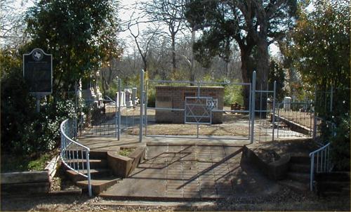
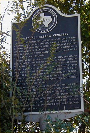
| Marshall Hebrew Cemetery |
|
Gate
Picture - Historical Marker Picture |
| Mason Springs Baptist Church Cemetery (AKA Pace Cemetery) |
|
African-American
- Located on Hwy 80, between Longview & Hallsville. |
| McAllister Cemetery |
|
See
Harkins |
| McJohnson Cemetery (AKA
Mack Johnson) |
|
See
Mack Johnson |
| McKay Cemetery (AKA
Hendricks) |
|
Abandoned. Across FM 31 from the Elysian Fields fire
tower on private property. |
| McPhail Cemetery |
|
From
Marshall go west on 154 to CR 4121 (McPhail Road). The cemetery is just
northwest of the intersection. |
| Meadows Family Cemetery |
|
Located
in the Grange Hall area. |
| Memory Park Cemetery |
[323017n, 0944108w] |
Located
on Hwy 80 at the edge of Longview just over the Gregg County line into
Harrison County. |
| Mimosa Hall Cemetery |
[323507n, 0940923w] |
From
I-20, exit 628, take FM 134 north about 7.2 miles from where it makes the
sharp right turn in Jonesville. Turn west on Mimosa Hall Road. Take the first
left and follow this road to the end, about 1.1 miles. The cemetery should be
straight ahead. |
| Minneweather Family Cemetery |
[323436n, 0941353w] |
African-American
- In Marshall, from the junction of Hwy 43 and Loop 390 east of Marshall, go
about 1.4 miles and turn east on CR 2200 (Marshall Leigh Road), a distance of
about 3.5 miles. Turn south onto an unnamed road. There is a locked
gate and the cemetery is on the east side of the road just under .2 miles
from Marshall Leigh Road. This unnamed road appears to be the second left
after crossing Hagerty Creek. |
| Moore Cemetery |
|
- |
| Mooty Ridge Cemetery |
|
Private
family cemetery off Hwy 449 |
| Morris Cemetery (AKA
Taylor or Williams Chapel) |
[323105n, 0943005w] |
African-American
- Take Hwy 80 west, cross Potter's Creek and then Cold Water Creek. The
cemetery is on the north side of the road about 1.8 miles west of Cold Water
Creek. It is about .4 miles before you get to a road heading off to the south
called Muntz Cut-Off (CR 31-2). It is across the highway from the
Williams Chapel. |
| Motley Cemetery |
[323207n, 0940910w] |
African-American
- From Waskom/ Jonesville, follow FM 134 north and west to FM 1998. Go west
on FM 1998 about .9 miles and turn south onto an unnamed road. This is the
first road on the left after crossing Buffard Creek. Cemetery is on the east
side of the road, past the Shiloh Church, less than .1 miles from FM 1998. |
| Mount Pleasant Cemetery |
[N 32.41 W 94.2153] |
African-American
- From Hallsville, take FM 450 north about 2.3 miles. Turn west onto Mount
Pleasant Cut-off. Cemetery will be on the north side of the road about .5
miles from FM 450. |
| Mount Prospect Cemetery |
[322436n, 0941255w ] |
African-American
- From Marshall, take Hwy 31 south to CR 1203 (Floyd Evans Road). The
cemetery is on the east side (left) of Hwy 31 near CR 1203. |
| Mount Zion Cemetery |
|
African-American
- Located on FM 1997. From Woodlawn, go west on FM 1997. The
cemetery is about 1/2 mile west at the Mt Zion Church. |
| Muckleroy Cemetery |
[323106n, 0942924w] |
From
Marshall, take Hwy 80 west, cross Potter's Creek and then Cold Water Creek.
About 1.1 miles after crossing the creek, turn south onto an unnamed road. Go
about .1 miles and the cemetery will be on the west side of the road. (There
may be a sign for Keoluk where this road leaves US-80.) |
| Munden-Jackson Cemetery |
|
- |
| Murrell Cemetery |
|
- |
| Nesbitt Cemetery |
[323524n, 0942652w] |
From
Marshall, take Hwy 154 north west approximately 3.8 miles from Loop 390. Turn
left onto Nesbitt Cemetery Road and the cemetery is on the east (left side of
the road. just before the road makes a sharp bend to the right. |
| New Grover Cemetery |
|
See
Grover Cemetery |
| New Prospect (AKA Smyrna) |
|
African-American
- From State Hwy 154 in Harleton, go NW on FM 450 for about 5 miles to
Davidson Rd. (black top road), turn left and go about 1 mile, where a green
& white county road sign "New Prospect Cemetery" on the left
will take you to the cemetery. |
| New Town Cemetery |
|
- |
| New Zion Cemetery (AKA Overstreet or Zion Hill) |
[323648n, 0942931w] |
On
private property. From Marshall, take Hwy 154 north west approximately
7.1 miles from Loop 390. Turn right onto an unnamed road just after having
passed Franklin Road coming in on the left. The cemetery is on the north side
of the road about .4 miles from Hwy 154. |
| Nicholas Cemetery |
|
- |
| Nichols Cemetery (AKA Old
Sudduth) |
[323238n, 0941913w] |
African-American
- In Marshall, from Hwy 80, take Merrill Street north to the end. The
cemetery is on the west side of the street. |
| Noonday Cemetery |
|
From
Marshall, Texas take Interstate 21 approximately 9 miles to Exit 604
(Hallsville/Lake of the Pines Exit). This exit will end at Farm to Market
Highway (FM 450). Turn right (North) onto FM 450. Travel North on FM 450 for
about 1.5 miles to Hallsville. In Hallsville, cross the railroad then the
traffic light and go 3.8 miles North. After passing the gated neighborhood
called “The Highlands” (formerly Hallsville Drag Strip), continue another 1
mile. The Noonday Cemetery will be on your right. |
| Oak Haven Cemetery |
|
On
the Oak Haven Recovery Center grounds northwest of Marshall on FM 154.
Only 2 marked graves. |
| Oak Hill |
|
African-American
- From Marshall, take Hwy 43 south to Cooks Road (CR 3018). Go about
1/2 mile past the Oak Hill church and the cemetery is on the right. |
| O'Connor Cemetery |
|
On
private property. Located on CR 4002 (Henderson School House Road), in
the woods. One marked grave, with many unmarked. Rev. O'Connor. |
| Old Blocker Cemetery (AKA
Blocker or Levin Perry) |
|
See
Blocker Cemetery #2 |
| Old Border Cemetery (AKA
Border) |
|
African-American
- Once used for white burials, now used for African-American burials.
Go East on I-20 to Waskom Exit 633. Turn North on 134 next to Catfish Village
Restaurant and go 3.8 miles and turn right on County Road 2713 (Concord Rd.).
Go 1.6 miles and the cemetery and church are on the right. After you turn on
2713, you will pass the Concord Cemetery on the right, but it is fenced and
has a lock on the gate. The cemetery is on the right hand side of the
church, and in the back. |
| Old Bullard Cemetery |
|
Abandoned. On the old Bullard property. Located
on FM 134 between Jonesville & Leigh. |
| Old Cole Cemetery |
|
|
| Old Davis Cemetery |
|
See
Davis #2 |
| Old Friendship Cemetery |
|
Located
on the Hallsville road, north of Noonday, north of LaGrone's Chapel, on
private property. Abandoned with many broken stones. |
| Old Grover Cemetery |
|
See
Grover Cemetery |
| Old Hope Cemetery |
|
Abandoned. On Caddo Lake Wildlife Refuge
[formerly-Longhorn Army Ammunition Plant]. |
| Old LaGrone Cemetery |
|
Abandoned. North of LaGrone's Chapel on private
property. |
| Old Macadonia Cemetery |
|
See
Macadonia |
| Old Powder Mill |
|
African-American
- See Powder Mill |
| Old Sudduth Cemetery |
|
See
Nichols Cemetery |
| Ole Webb Cemetery |
|
4
½ miles SE of Marshall on the Elysian Fields Hwy. From Marshall, go
south on Hwy 31 for about a mile, then turn left on CR 1017 (Joe Road).
Follow it north past a curve to the right and then an immediate left.
The cemetery is behind the last abandoned house on the right. Very
difficult to find. |
| Oscar Hope Cemetery |
[324036n, 0941018w] |
From
Karnack, take FM 134 north approximately .7 miles and turn east onto an
unnamed road. If you get to the junction with FM 2198, you missed it.
Cemetery is at the end of this unnamed road. |
| Overstreet Cemetery |
|
See
New Zion |
| Pace Memorial Gardens |
|
Off
Hwy 80 between Longview & Hallsville. When you see the Mason
Springs Baptist Church, cross the railroad tracks and turn right at the
bottom of the hill. The cemetery will be close to the end of the road
on the left. |
| Perry Cemetery (AKA Saunders) |
|
Private
property. Located off FM134 between Jonesville and Leigh about two
miles back in the woods on what was the old Perry Farm. |
| Pine Bluff |
|
African-American |
| Piney Cemetery |
[324040n, 0943117w] |
From
Hwy 154 just south east of Harleton, take FM 2208 north east for about 1.9
miles. Turn north onto an unnamed road. At a junction, bear right and go
the end of the road. On FM 2208, if
you get to McPhail Road going off to the right, you missed the turn. |
| Piney Grove Cemetery |
[322135n, 0942100w] |
African-American
- From Marshall, go south on Hwy 59. From the junction with FM 1186, continue
about 1.9 miles. The cemetery is on the west side of the road just before Tom
Woodley Road goes off to the west. (Located at the intersection of CR 3031
(Gray Road) & CR 3029 (Tom Woodley Road) on Hwy 59.) |
| Pink Hill (AKA
Muckleroy) |
|
African-American
- See Muckleroy |
| Pleasant Hill Baptist Church Cemetery |
|
African-American
- From Marshall, TX: Take I-20 West to the exit for FM 450 (Hallsville), take
FM 450 South approx. 2 miles to FM 968. Take a left on 968 go 2 miles and
there is a cemetery sign, turn right at the sign onto Hut Horton Rd, and the
cemetery is about 1 mile down a dirt road. |
| Pleasant Hill Cemetery |
|
African-American
- In the Leigh area. From Leigh, take CR 1999 east to Hwy 9. Go
south on Hwy 9 to CR 2701 (Trice Road). The cemetery is on Trice Road. |
| Pope City Cemetery (AKA
Pope Cemetery) |
[3241.09n
09418.41w] |
From
Marshall go north on US-59 to Woodlawn. Take Black Jack Road east, past the
Woodlawn Oil Field, to CR 2012 (Pope City Road). Turn south east and follow
this to Pope City. The cemetery is behind the Pope City Baptist Church. |
| Potters Creek Cemetery |
|
African-American
- Located on Hwy 449 (Hynson Springs Rd) east of Hallsville near Bailey
Cutoff just across from Potters Creek Church . "It is a Colored
church & cemetery that has been there for years and years." The
cemetery is on the south side of FM 449 , about 100 yards down a lane
with a big gate. |
| Powder Mill Cemetery |
|
African-American
- Joins Old Powder Mill. In Marshall, north of East Texas Baptist
University on the east side of North Grove Street (FM 1997). |
| Raine Cemetery |
|
- |
| Red Oak Cemetery |
|
African-American
- Located in the south Hallsville area. It is down a lane that exits to
the north from FM 3251 at the intersection of FM 3251 & CR 3200 (Red Oak
Road). |
| Restland Cemetery |
[322904n, 0940302w] |
In
Waskom, find the Lions Club Park on Jefferson Street. Take Jefferson east
about .3 miles from the park. Turn north on a road that is not named in
Street Atlas USA. The cemetery is on the east side of the street, about .4
miles up from Jefferson Street. |
| Richardson Cemetery |
|
Abandoned. On private property at the Old Barnes
place. |
| Rock Springs Cemetery |
|
African-American
- In Scottsville, next door to the Scottsville Cemetery on FM 1998. |
| Roe Page Cemetery |
|
On
private property. Go north on Hwy. 259 until you get to FM 449. It will only
go to the right. This will be just shortly after leaving the Judson Road
area. Turn right on 449 and you will go several miles to the east until you
reach a 4 way intersection that is FM 2879. Turn left, or back to the north.
The Bussey place is not far on the right. |
| Rogers - Scott Cemetery |
|
On
Quail Lane off FM 968, south of Hallsville. |
| Rose Hill Cemetery |
|
African-American
- Take Hwy 80 east from Hallsville. Go about 1 mile past Muntz Cutoff Road
and cemetery will be on left just off of Hwy. 80. |
| Roseborough Springs Cemetery |
|
- |
| Saint James Cemetery |
[323829n, 0942623w] |
African-American
- From Marshall, take Hwy 154 north west about 4.25 miles from where it
leaves Loop 390, to Nesbitt. Turn north on Callaway Road and go about half a
mile before turning east onto Futrell Road. Follow Futrell Road for about 4.1
miles until it runs into Macedonia Road. Turn left onto Macedonia Road. In
about .5 miles, Macedonia Road becomes CR 4118 (St. James Road). In about
half a mile, you come to a fork., with St. James Road continuing to the
right. Take the left hand (no name) fork. At the end of this road, about .3
miles, the cemetery will be on the east side of the road. |
| Saint Johns Cemetery |
|
African-American
- On CR 1019 (Blocker Road), behind the St John's Church. |
| Saint Joseph's Cemetery
(AKA Catholic Cemetery) |
[323228n, 0942128w] |
In Marshall, from Hwy 59, take Travis Street west about .5 miles.
Just beyond Doty St, the cemetery will be on the south side of the road.
(This is about the 900 block.) |
| Saint Marks Cemetery |
|
|
| Saint Mary's Baptist Church Cemetery |
|
African-American
- From Marshall take Hwy 43 south to CR 2625. Turn east (left).
Go to CR 3042 (Peach Orchard Road) and turn left. The cemetery is
behind the Saint Mary's Church. |
| Saint Paul's Cemetery |
|
See
Hudson Cemetery |
| Saunders |
|
See
Perry Cemetery |
| Scott Cemetery |
[322628n, 0943528w] |
African-American
- From Marshall, take Hwy 43 east to CR 2200 (Marshall-Leigh Road).
Turn right on CR 2200. The cemetery is at the intersection of CR 2200
and CR 2213 (Harkins Lane). |
| Scottsville Cemetery |
|
Next
door to Rock Springs Cemetery on FM 1998 in the Scottsville Community. |
| Scratch Eye Cemetery (AKA
Wilson's Chapel) |
|
From
Marshall, take Hwy 154 about 2.5 miles west to CR 4308 (Hayne's Road).
The cemetery is on Hayne's Road. |
| Shady Grove Cemetery |
[322206n, 0941755w] |
African-American
- From Marshall, go south on Hwy 59 about 7.2 miles to FM 1186, which
branches off towards the south east. Follow this 2.6 miles, until CR 145
(Acie Rhodes Road) goes off to the east. Take this for about .6 - .7 miles.
Cemetery is on the north side (left side) of the road. |
| Sherrill & Hamilton Family Cemetery |
|
On
private property. Located west of Woodlawn on CR 4004 (Jewell Gooch
Road). From Woodlawn, take FM 1997 west to CR 3001. Take CR 3001
to Driskell Bridge Road. Turn left on Driskell Bridge Road. At CR
4004 (Gooch Road), turn left. It is about a 1/4 mile from CR 4007,
about 100 yards in the woods, enclosed by a cyclone fence. About 100
yards east of this is a brick enclosed plot with 2 graves. These graves
were there in 1852 when the Sherrills bought the land. |
| Sherrod Cemetery |
[323635n, 0941510w] |
African-American
- In Marshall, from the junction of Loop 390 and 43, take Hwy 43 northeast
about 2.7 miles to CR 2115 (Pine Bluff Road). Take CR 2115 (Pine Bluff Road)
north about 2 miles to a 'Y' junction. Take the right-hand fork for about .4
miles and the cemetery will be on the north side of the road on the Carlisle
Hunting Club property. |
| Sherrod Cemetery |
|
Abandoned. Located on private property on FM 2199
south of the I-20 intersection. |
| Sim - Foshee Cemetery |
|
|
| Simmons Cemetery |
|
See
Bluff Springs |
| Sims Cemetery |
|
Abandoned. On private property on CR 2718 (State Line
Road). |
| Sipps Cemetery |
|
African-American
- From Karnack, take Hwy 43 north to Hwy 134. Go west on Hwy 134 until
you come to Lake Cooper Road. Turn left on lake Cooper Road. When
you come to CR 2108 (Peter's Chapel Road), turn right. The cemetery is
on this road behind an iron gate. |
| Slave Cemetery |
|
African-American
- In Hallsville. |
| Smyrna Cemetery |
[N32 43.608' W094
37.787'] |
From
Marshall and highway US 80, turn west on SH 154 for 16 miles to Harleton. At
Harleton, turn right on FM 450 for the cemetery. (From Ore City turn
south from US 259 onto FM 450 for the cemetery.) |
| Spring Valley Cemetery |
|
African-American
- From Marshall, take Hwy 43 south to CR 2625. The cemetery is about
100 yards east of this intersection. See the people in the small brick
house. |
| Springhill Cemetery |
[323111n, 0943226w] |
African-American
- From Hwy 80 between Marshall and Hallsville, take Old Hwy 80 loop to Young
Road, which goes off to the northwest. At the end of Young Road, turn right
onto CR 3803 (Hickey Road). Go about .3 miles, and the cemetery will be on
the east side of the road. Originally founded by Edd Whitehorn.
Numerous whites were buried there originally, but there are no markers for
them. The cemetery is now used for African-American burials. |
| Strickland Springs Cemetery |
|
From
Marshall, go east on I-20. Turn right/south on Hwy. 31 to community of Cross
Roads. Take a left on Hwy. 2625 (go for several miles) to Strickland
Springs Road and take a right. The cemetery is behind the Strickland Springs
Baptist Church. |
| Strickland Springs Cemetery (Old) |
|
Located
on Gilmer Farm (private property) on oiled road in south east part of
Harrison Co. From Waskom, take Hwy 80 west to Hwy 9. Go south on Hwy 9.
Take CR 2625 to CR 1205 (Strickland Springs Road). Go south (left) on
CR 1205. The cemetery is on the Gilmer Farm. |
| Sunny Hill Cemetery |
|
African-American
- In Marshall, from loop 390, take Hwy 154 west to CR 4210 (Center Hill
Rd). The cemetery in on CR 4210 at the Sunny Hill Church. |
| Swanson Cemetery |
[323559n,
0940441w]: |
Abandoned. Located in Leigh, take CR 1999 east for
approximately 3.3 miles, just past Watson Bayou. Take the first road going
south past the bayou and go about .4 miles. Cemetery is on the west side of
the road near the Boone Home on private property. |
| Sweet Home Cemetery |
|
African-American
- Located at the intersection of FM 968 and I-20. |
| Sypert Cemetery |
|
Abandoned. East of Hallsville. From Hallsville
go east on Hwy 80, turn left on CR 3811 (Sabine Lumber Cutoff) and the
cemetery is on the east side (right) of the road. All that is left is a
concrete slab with names and dates. |
| Tage Cemetery (AKA Taylor Family) |
[323515n, 0942728w ] |
African-American
- On private property. In Marshall from Loop 390, go west on Hwy 154
approximately 4.5 miles. Just past Oak Haven Home, turn south (left) onto CR
4308 (Haynes Road). Go south for .5 miles; the cemetery is on the west side
(right) of the road. |
| Talifiaferro Cemetery |
|
- |
| Taylor Cemetery |
|
See
Morris Cemetery |
| Taylor Family Cemetery |
|
See
Tage Cemetery |
| Timmins Cemetery |
|
Located
about 3/4 of a mile north of the Bethel Camp Ground, which is located on what
was known as Timmins Farm. |
| Timmons |
|
See
Harkrider |
| Tuckers Chapel Cemetery |
|
A
Harrison County obit listed someone as being buried here, but we can find no
record of this cemetery. If you have any information that would help
confirm or identify this cemetery, please email the County Coordinators
listed on main page. |
| Union Church Cemetery |
|
African-American
- Located on CR 2730 (State Line Road) at the Union Church. |
| Unknown Cemetery #1 |
|
Abandoned. African-American - In the Hallsville area
on CR 3430 (Appaloosa Lane). |
| Unknown Cemetery #2 |
|
Abandoned. In the Leigh Community. In the
northwest corner of the intersection of CR 1999 and 2618. |
| Vaughan Cemetery |
|
Private
property in Jonesville community on Hwy 134. |
| Walnut Creek Cemetery |
|
This
could be Walnut Creek Cemetery located in Diana, Upshur County, Texas. If any known cemetery by this name in
Harrison County, please contact the County Coordinator of this site. |
| Ward Family Cemetery |
|
Located
east of Hallsville. From Hallsville, take Hwy 80 east, turn left on CR
3811 (Sabine Lumber Cutoff Road). The cemetery is on Young Road, which
is left off of the Sabine Lumber Cutoff Road. Reported to be on private
property on the Ben Ward Plantation. |
| Ware Cemetery |
|
See
Blocker Cemetery #1 |
| Waskom Family Cemetery (AKA Lary-Waskom) |
|
Waskom,
in a field near the ARK-LA Gasoline Plant. Across the road from the St
Joseph's Catholic Church. Only 2 marked graves. |
| Webb Cemetery |
|
Abandoned. On private property. Off Hwy 31, 5
miles south of Marshall. |
| Webster Cemetery (AKA Webster Blocker) |
|
From
the Leigh Community, take Hwy 134 south, turn right on Mimosa Hall
Road. On private property on the old Blocker Plantation. |
| Wells Family Cemetery |
|
Abandoned. From Harleton, take Hwy 450 south.
Turn left onto CR 4312 (Ferguson Road), then turn right onto CR 4313 (Wells
Road). |
| Whites Cemetery |
|
African-American
- Located at the end of CR 3200 (Red Oak Road), in the south Hallsville area. |
| Wiley College Cemetery |
[323118n, 0942242w] |
African-American
- From Hwy 59, take Hwy 43 west to Roseborough Springs Road. Go south two
blocks to Lancaster St., then west one block to Achte St. Go south on Achte
to the end and cemetery is just off to the south-west. (This will get you in
the ball-park.) |
| William's Chapel Cemetery |
|
See
Morris Cemetery |
| Wilson's Chapel |
|
See
Scratch Eye Cemetery |
| Woodlawn Cemetery (AKA Bethesda) |
[323916n, 0942107w] |
From
Marshall, go north on Hwy 59 about 5.75 miles from where it crosses Loop 390.
You will pass Timberland Road on the right. Just beyond that on the left, as
the railroad tracks swing in to parallel the highway, there is an unnamed
road going to the west. Turn onto this road and go about .3 miles which will
bring you to Memory Lane. Cross Memory Lane and there is a small loop road
that will bring you to the cemetery. |
| Woodley Cemetery |
[322107n, 0941446w] |
From
I-20, exit 617, go south on Hwy 59 about 7.2 miles to FM 1186, which branches
off towards the south east. Follow this 3.9 - 4.0 miles. Turn east onto West
Road. (West Street is almost opposite Cook Road which goes off to the west.)
Follow West Road for about 2.8 miles. The cemetery is just on the north side
of the road at the intersection with Haynes Road. You may actually cross the
county line just as you get to the intersection, but the cemetery is in
Harrison County. |
| Yates Memorial Cemetery |
|
Adjacent
to Scottsville Cemetery, located on FM
1998. From Marshall, go east on Hwy 80, turn left on FM 1998. |
| Young Cemetery |
|
On
private property, it is Located about two and a half miles east of the
Noonday Community near Hallsville. |
| Zion Hill Cemetery (AKA
New Zion) |
|
See
New Zion |